Protecting carbon rich landscapes is a critical natural climate solution. That’s why The Trust for Public Land and American Forests developed the Forest Carbon Map, a web-based tool that quantifies existing forest carbon stocks across the United States.
Forest Carbon Map
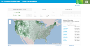
The Trust for Public Land & American ForestsThe Forest Carbon Map makes the most recent U.S. Forest Service data available in an easy to use web interface that allows users to: (1) pinpoint carbon-rich landscapes; (2) quantify the amount of carbon stored; (3) identify threats to those carbon stocks; and (4) make informed land protection or policy decisions that factor in carbon and other critical co-benefits.
The tool runs on a simple web platform that allows users to view carbon stocks at the national, state, and county level. In addition, parcel-level carbon data is available for the first 15 U.S. Climate Alliance states. These data are available for parcels greater than 100 acres.
The analysis can be further broken down by carbon type (above ground, below ground, etc.) and ownership (public, private, or all lands). Users can also analyze threats to those carbon rich landscapes (wildfire, disease and pests, or development) and potential co-benefits of land conservation efforts (protecting habitat cores, rare ecosystems, and headwaters). Every analysis can be summarized and downloaded as a PDF report.
The Forest Carbon Map in action: The Trust for Public Land, with support from TNC, led a feasibility study for the state of Wisconsin to lay out a path for scaling-up natural climate solutions using new policy and funding mechanisms. The Forest Carbon Map was used to quantify existing carbon stocks and provide a concise summary for agency heads and others on the importance of protecting and expanding forest carbon. The tool was also used to submit testimony to the New York legislature, successfully advocating for forests to be considered in New York’s Climate Leadership and Protection Act. And finally, the Carbon Map is being used by land trusts and universities to evaluate and prioritize climate conservation efforts.
Check out the tool here, and explore how this resource can support your work.
For questions, comments, or to share how you’re using the tool – please email Taj Schottland: taj.schottland@tpl.org