![]()
Questions that this tool can answer:
- What counties provide the most “bang for the buck” when planning Reforestation?
- How should my state structure and target incentive programs to support reforestation on the most promising private lands?
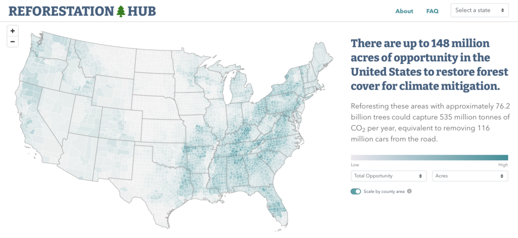
Reforestation of previously forested lands has the potential to capture up to 333 million metric tons of carbon dioxide in the U.S. – a quarter of U.S. annual emissions from cars and light-duty trucks. The Reforestation Hub – a joint project of The Nature Conservancy and American Forests – can help land managers, policy makers, and businesses identify which counties have the greatest opportunity for reforestation, how that land is currently used, and what benefits reforestation can offer at that location.
The data identify “areas of opportunity” for reforestation within each county, tallying how much carbon could be captured by reforestation. These areas of opportunity represent lower cost and more feasible options for restoring forest cover – including lands already in natural land use, marginal agricultural lands, post-burn landscapes and areas where trees can provide additional benefits, like flood protection and urban heat relief. Native grasslands, highways, urban cores, wetlands and productive croplands are excluded, except those within floodplains and next to streams and migratory pathways for animals. In addition to mapping these opportunities, the Reforestation Hub provides links to additional information about how to best plant trees.
The Reforestation Hub is an invaluable resource for policy makers to assess the magnitude and location of reforestation opportunities across the United States. As new federal funding for reforestation becomes available, this tool can be used by federal agencies, states, non-profit organizations and private landowners to inform the on-the-ground implementation of these programs.