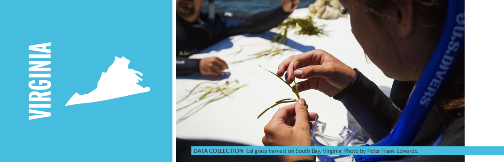
I remember the exact moment when I began my relationship with seagrass: rooted, flowering plants growing completely underwater in a shallow lagoon off the Florida Keys. It was my 21st birthday, and I was far from my Eastern Shore of Maryland home and college, immersed in a Tropical Marine Ecology “winter-mester.” My fins and dive gear were brand new, as was my scuba certification.
I forgot everything I had learned in my scuba training as I pulsed through the most beautiful, submerged ecosystem I had ever seen. It took my breath away—literally. My dive partner had to circle back to check on me. I tried to speak to her with bubbles and gestures: “Have you seen this grass? Have you seen the fish and other animals in this grass? The sandy bottom? Have you ever experienced anything like this?”
“I mean, sure, it is beautiful,” her eyes said to me through her mask. But come on, let’s swim to the coral reef!”
That experience changed the entire trajectory not only of my professional life, but also my entire life.
In Virginia, the water in our temperate eelgrass beds is not as clear as in that tropical system. But the seahorses, the fish, the blue crabs, the amazing way the grass holds sediment and captures wave energy—it all still takes my breath away. And the fragility of these meadows. Though able to alter the water clarity with roots and rhizomes holding the sediment in place, they can be harmed by runoff from the land that brings excess nutrients and sediments, blocking light essential for survival.
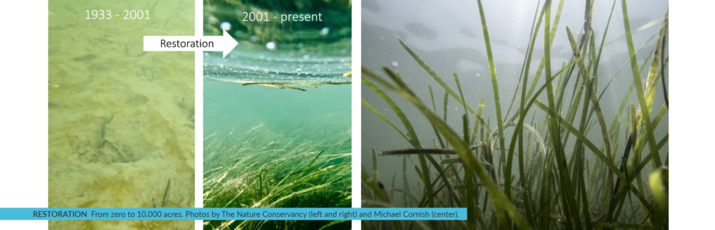
The story of eelgrass along the East Coast of the U.S.—human impacts, loss and disease taking hold to strangle out this vital underwater “forest”—is one that has been repeated across the globe. Here off Virginia’s Eastern Shore, eelgrass disappeared from our coastal lagoons in the 1930s. Zero. We were down to zero acres, and all the benefits of this grass—habitat, refuge, erosion control, atmospheric carbon capture—disappeared with it. Then, in the late 1990s, scientists found a small patch of eelgrass1. They had been my colleagues back during the first seagrass experiences, when I was a graduate student at the Virginia Institute of Marine Science (VIMS).
The Nature Conservancy and partners had invested in the conservation of this barrier island coastal system for decades, so maybe the protected water quality here in these shallow lagoons would support eelgrass once more?
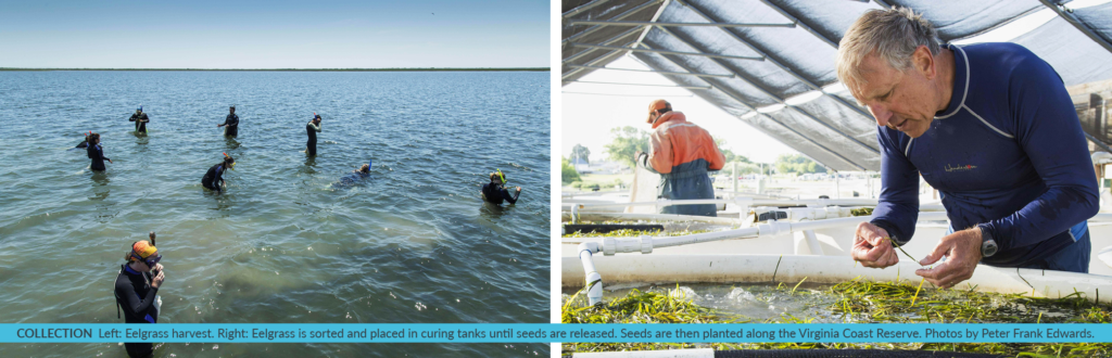
Using a simple seed-dispersal technique, scientists and volunteers from all over the world have contributed to what is now 10,000 acres of thriving eelgrass in the Virginia Coast Reserve (VCR). This local restoration is now informing global science and recovery as well as providing further improvements to local water quality, five times more fish abundance, higher blue crab densities, return of bay scallops and capture and storage of atmospheric carbon in the soil and plant material. In twenty years, these seagrass meadows have captured 5,000 tons of carbon— equivalent to the yearly carbon dioxide emissions of 3,500 cars!
Our coastal systems are among the most studied in the world— and home to the University of Virginia’s Long Term Ecological Research program2. And here is where a methodology to quantify the amount of carbon that is being sequestered in seagrass beds was developed. Methodologies for carbon projects provide the procedures for quantifying greenhouse gases in habitats, like restored eelgrass beds. Standard-approved methodologies are used to generate carbon offsets, which can be sold on the voluntary market.
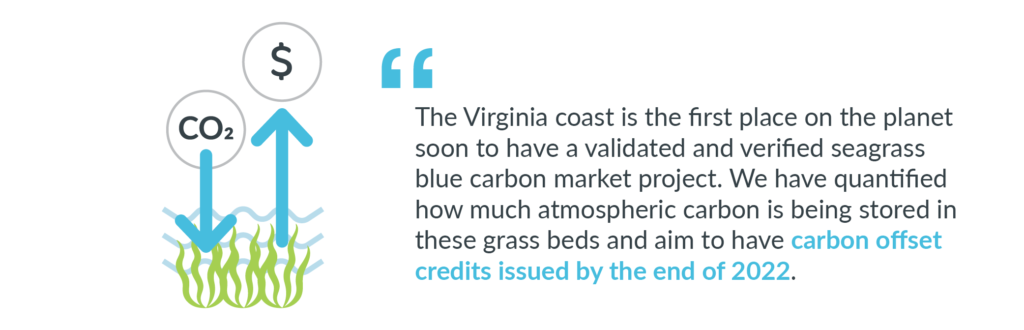
The restored eelgrass in Virginia’s coastal bays is one of the great large-scale success stories in marine restoration, and now it’s the first place on the planet soon to have a validated and verified seagrass blue carbon market project. We are now in the final stages of the approval process. We have quantified how much atmospheric carbon is being stored in these amazing grass beds and aim to have carbon offset credits issued by the end of 2022—establishing a model for similar seagrass restoration projects worldwide.
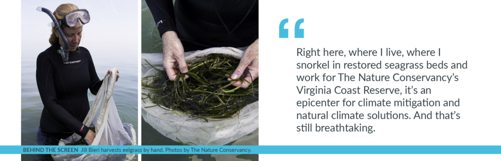
Since the Commonwealth of Virginia owns the sandy bottom on which this successful restoration has taken place, state legislation was proposed, supported, and passed in 2020 allowing carbon market participation by the Commonwealth. This legislation stipulates that revenue generated would be used for further monitoring and research in these eelgrass beds—a win-win for the state. This brings the project full-circle, as 20 years ago, initial funding for this endeavor was provided by Virginia’s Coastal Zone Management program. Right here, where I live, where I snorkel in restored seagrass beds and work for The Nature Conservancy’s Virginia Coast Reserve, it’s an epicenter for climate mitigation and natural climate solutions. And that’s still breathtaking.
Please visit the Virginia Coast Reserve website to learn more.
1 In the 1990s, scientists from the Virginia Institute of Marine Science (VIMS) found a small patch of eelgrass and figured out how to restore it in this system. They have spearheaded the restoration work ever since.
2 The University of Virginia’s Long Term Ecological Research program developed the methodology that is being used to quantify the amount of carbon that is being sequestered in seagrass beds.
The Nature Conservancy is restoring the hydrology of peat soils in coastal North Carolina to combat climate change.
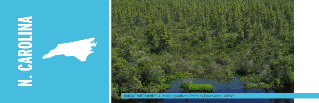
The Atlantic coastal plain along the Southeastern United States (SE US) holds powerful potential in its peatlands. These unique wetlands store carbon from waterlogged plant material dating as far back as 10,000 years. But they also capture carbon across their living landscape of forest and shrub communities.
Like many other peatlands across the world, large portions of the network of bogs and swamp forest that once stretched over millions of acres in the SE US have been ditched and drained. Restoring these drained peatlands is proving to be a critical natural climate solution.
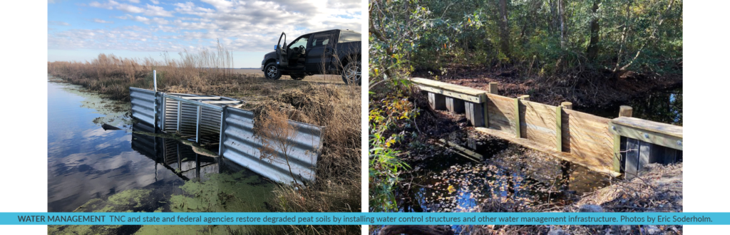
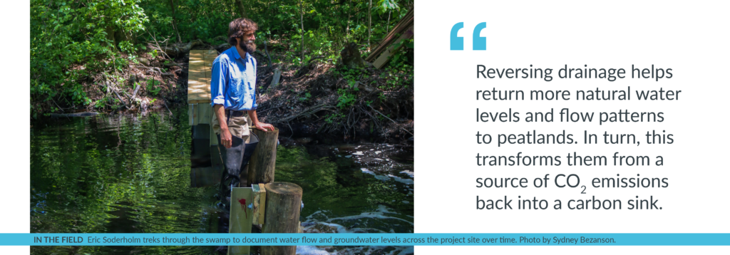
“This work is a giant plumbing job of sorts,” says Eric Soderholm, restoration specialist for The Nature Conservancy (TNC) in North Carolina. “Reversing drainage helps return more natural water levels and flow patterns to peatlands. In turn, this transforms them from a source of carbon dioxide emissions back into a carbon sink.”
Peatlands are a type of wetland whose soils contain a high amount of partially decayed organic matter that has accumulated very gradually over thousands of years. They retain an incredible amount of carbon in their ever-growing layer of peat soil. Peatlands cover just 3% of the earth’s surface but store more than twice the carbon as all the world’s forests combined. They span tropical rainforests, permafrost regions and coastal areas.
Approximately 1.2 million acres of peatlands in the Southeastern U.S., and 70% of those found in North Carolina, have been ditched and drained. Drained peatlands emit carbon dioxide. Restored peatlands retain carbon. Think of it this way: 10 acres of natural, undrained peatlands in the Southeast can remove 5.3 passenger vehicles’ emissions in a year. In contrast, 10 acres of drained peatland can add 21.5 passenger vehicles’ emissions. Yet, this comparison does not even consider emissions from peatland wildfires. Due to its rich carbon content, unnaturally dry peatland soils are highly flammable. This makes them vulnerable to more frequent and intense catastrophic wildfires that can burn several feet deep into a peatlands soil and belch huge quantities of carbon dioxide in a single event.
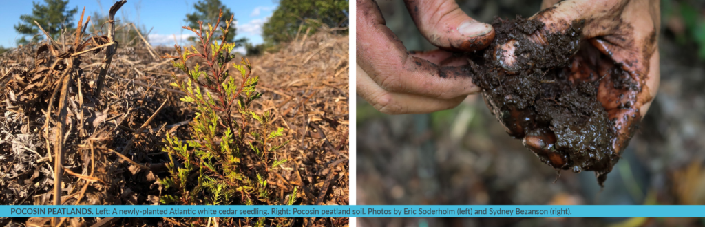
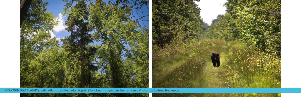
The Nature Conservancy in North Carolina and its partners have been steadily restoring peatlands including portions of the U.S. Fish and Wildlife Service’s Great Dismal Swamp, Pocosin Lakes and Alligator River National Wildlife Refuges. The distinctive peatlands found on the coastal plain from Virginia to Georgia represent many wetland communities that are broadly called “pocosin”, an Algonquin word. Plants here are diverse, yet all share an affinity for soggy soil conditions: pond pine, Atlantic white cedar, swamp tupelo, cypress, loblolly bay, inkberry, fetterbush, canebrake, pitcher plants, cranberry, sphagnum moss. If you grab a handful of pocosin peatland soil, half of what you are holding is carbon.
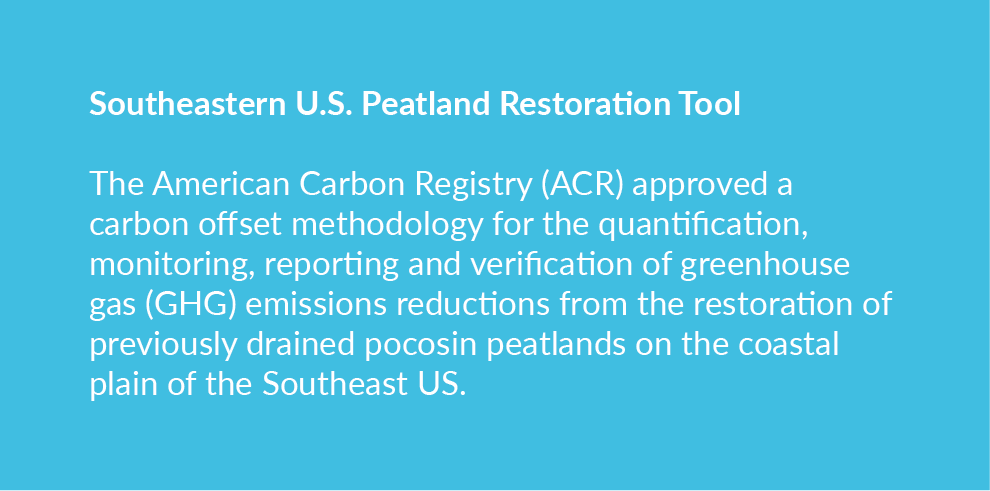
TNC developed this one-of-a-kind carbon methodology with TerraCarbon, a carbon offset project and natural climate solutions advisory firm. The methodology has been put into practice at a 1,241-acre proof-of-concept restoration site within Pocosin Lake National Wildlife Refuge, in partnership with the US Fish and Wildlife Service. Much of the peatland that remains drained in the SE US is privately owned. This tool allows landowners to register new projects with the American Carbon Registry to generate and sell verified carbon credits on the voluntary carbon market based on the emission reductions achieved by a peatland rewetting project. Income from the sale of verified carbon credits can help cover upfront restoration costs required to successfully rewet and monitor drained peatlands.
Eric Soderholm leads TNC’s work to restore peatlands in North Carolina, partnering with state and federal agencies to restore degraded peat soils by installing water control structures and other water management infrastructure throughout each project site.
On his days monitoring TNCs most recent restoration project within Great Dismal, Soderholm treks through the swamp to document water flow and groundwater levels across the project site over time. “It is fascinating to watch water return to the peatland,” says Eric Soderholm. “Once we know how water moves and fluctuates, Refuge staff can use this information to adjust that water flow to maximize both the habitat and flood resilience enhancements restoration provides.”
When peat soils are rewetted, they are much less flammable and create conditions for more diverse and resilient wetland forest communities to thrive. Since peat soils also have the great potential to sequester carbon when saturated with groundwater, restoring more natural water patterns in peatland is a natural climate solution. Most recent conservative estimates from the Duke University Wetlands Center suggest that if the remaining drained peatlands in the SE US were restored, emission reductions of at least 2.66 million metric tons of carbon dioxide could be achieved every year.
Once the “plumbing” is right at a peatland restoration site, rewetted conditions allow the re-establishment of peatland specialist native plants such as Atlantic white cedar. Cedar-dominated forests, which are now a globally threatened community, thrive in peaty, moist soil of swamps and bogs. Peatlands also support a variety of wildlife. Many songbirds, such as the prothonotary warbler, seek refuge there in spring. In the summer, black bear forage and enjoy the extra sun.
People also benefit. Improvements on Refuge lands help slow down and absorb storm water before it reaches a farming community just downslope from restoration sites, potentially reducing damage to crops and property.
Likewise, restoring peatlands vastly reduces the risks to human health and community safety associated with the numerous catastrophic peat wildfires this region has recently endured. A study following North Carolina’s 41,000-acre Evans Road peatland fire in 2008 determined that emergency room visits for cardiopulmonary complications increased significantly in the counties exposed to its toxic peat smoke.
Pocosin peatlands naturally sequester nitrogen and mercury which leach from drained sites at much higher rates. Restored sites with water control infrastructure help to reduce the quantity of these contaminants entering our rivers and sounds, both of which can impact aquatic communities and commercial fisheries.
TNC initially focused its partnership efforts to restore peatlands at sites on federal lands across the coastal plain. The organization is now moving south to state lands managed by the North Carolina Wildlife Resource Commission at Angola Bay Game Land. There are still large swathes of peat to be restored from Virginia to Georgia. TNC’s implementation work and partnership with researchers has helped lay the groundwork for that restoration. One of the next most critical steps is to expand restoration progress to the significant acreage of privately-owned drained SE US peatlands.
Interest from carbon project developers to work with private peatland landowners has continued to grow since the release of the ACR carbon offset methodology. Layering carbon finance with both existing and emerging state, federal and other funding sources is beginning to create the incentive needed for landowners to pursue the many benefits peatland restoration projects can yield.
“We’ve worked diligently with our partners to get the plumbing right at many sites in Northeastern North Carolina,” says Eric Soderholm. “This work has helped to demonstrate what can be accomplished elsewhere.”
Why are peatlands being degraded or destroyed?
European settlers gradually drained peatlands along the coastal plain at first to reach high value timber for human settlement and export and for agricultural conversion. Technological advances in modern excavation equipment fueled a boom in the 20th century to convert peatlands to agriculture, pine plantation and experiment with mining peat as a fuel source. However, significant acreage that was previously drained and logged are no longer in any active productive use yet continue to experience the negative impacts from historic ditch networks. Developmental pressures continues to loom for some of these special natural areas.
Why does peat burn?
Peat is highly flammable when dried. When wildfires occur in degraded, dry areas, they have devastating impacts on the land, as they can continue to smolder for long periods of time. Their emissions can also affect human health.
How can landowners get involved?
Landowners can access the peatland restoration methodology through the American Carbon Registry.
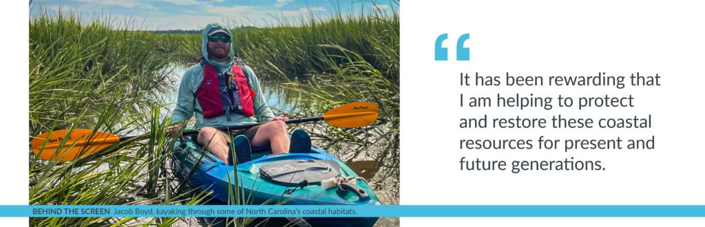
For most of my life, I have lived along the North Carolina coast enjoying my time spent in its coastal habitats and admiring its natural beauty. These experiences are an integral part of who I am. After I completed my undergraduate degree, my time spent appreciating the coast motivated me to begin a job as a Fisheries Technician for the North Carolina Division of Marine Fisheries. As my career has progressed with the division, it has been rewarding that I am helping to protect and restore these coastal resources for present and future generations.
As the Habitat Enhancement Section Chief for the North Carolina Division of Marine Fisheries, it’s my job to lead my team of highly skilled individuals to manage and coordinate large-scale restoration, management and enhancement programs – such as the North Carolina Coastal Habitat Protection Plan (CHPP) – for the diverse and critical habitats in our nearshore, coastal and estuarine areas that support the state’s commercial and recreational fisheries. The overarching goal of the CHPP is for long-term enhancement of coastal fisheries through habitat protection and enhancement efforts including conserving coastal ecosystems like salt marsh and seagrasses which provides many benefits to the state.
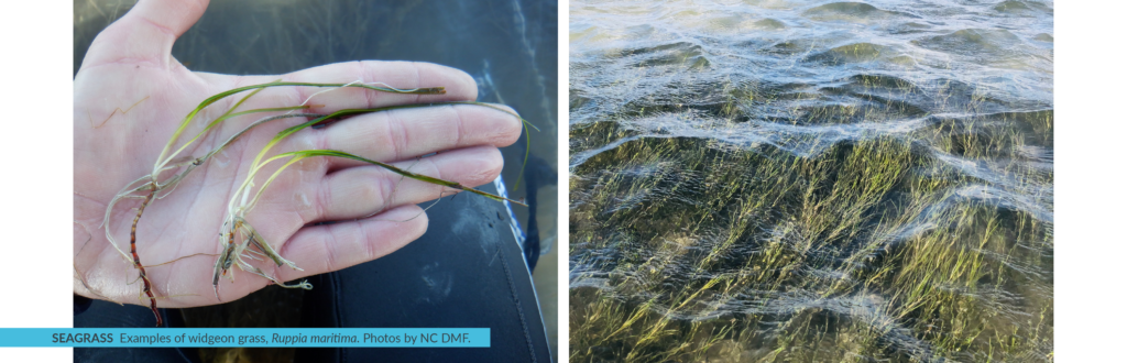
North Carolina has over 220,000 acres of salt marsh and the largest extent of seagrass coverage along the Atlantic coast, measuring approximately 105,000 acres in 2013. Seagrass is a common term used to define high salinity submerged aquatic vegetation (SAV), which is habitat characterized by the presence of plants that are rooted into the ground and remain under the surface of the water during all tidal stages. The foundation of North Carolina’s coastal economy is based on the abundance of healthy habitats in its 2.9 million acres of coastal waters. Fishing, outdoor recreation, and tourism all depend on a healthy ecosystem. In addition to providing a critical home for fish, coastal habitats help reduce the impacts of severe storms, improve water quality, support birds and other wildlife, and sustain culture and a North Carolina way of life. Unfortunately, increasing stressors from a variety of land use activities, coupled with climate change, threaten the health and sustainability of the state’s coastal ecosystems. Protecting and restoring these areas so that they can continue to deliver important benefits to people and nature is key. Over the last two years, researchers and managers have been assessing another benefit provided by these coastal habitats – slowing climate change.
Coastal wetlands, including salt marsh, seagrass, and mangroves, are incredibly efficient at capturing and storing carbon in their leaves, stems, roots, and soils. Blue carbon is a common term used to define carbon captured by the world’s ocean and coastal ecosystems. Coastal wetlands can keep this blue carbon locked away for thousands of years if left undisturbed. However, when these ecosystems are degraded, stores of carbon and other greenhouse gases (GHGs) are released back into the atmosphere, which can accelerate climate change. Given their carbon storage benefits, many U.S. coastal states, including North Carolina, and countries around the world, are interested in protecting and restoring blue carbon habitats as part of their climate response strategies.
A key first step to account for the carbon captured and stored in these habitats is through the development of a GHG inventory. Accounting for coastal habitats in GHG inventories is relatively new – the U.S. EPA began incorporating coastal wetlands into the national GHG Inventory in 2017, and in 2022 started making these data available to states. But – until now – national and state inventories have lacked a key habitat – seagrass beds. North Carolina is poised to address this omission.
In 2018, Governor Cooper of North Carolina signed Executive Order 80 – North Carolina’s Commitment to Address Climate Change and Transition to a Clean Energy Economy – which includes a statewide goal to reduce the state’s GHGs to 40% below 2005 levels by 2025. The Natural and Working Lands Action Plan, published in 2020, outlines specific projects in the Natural and Working Lands (NWL) sector – including coastal habitat protection and restoration – that advance North Carolina’s climate goals by enhancing carbon sequestration, building community and ecosystem resilience, and supporting local economies.
Several subcommittees, including the Coastal Habitats Subcommittee that I chair, contributed to the recommendations of the Natural and Working Lands Action Plan and continue to support its implementation. One of the next steps spawned by the plan is the development of a GHG inventory for the state’s coastal wetlands, including emergent, scrub shrub and seagrass habitats, to help us better understand how much blue carbon is captured and stored in these areas, and what management steps we can take to enhance our blue carbon resources. As the chair of the Coastal Habitats group, I am technically in charge of the inventory development process, but I have two great champions in Paul Cough and Chris Baillie, who are leading this effort with a stellar working group comprised of federal and state agency staff, NGOs, academics, and GHG inventory experts. Once finished, North Carolina will have one of the world’s first blue carbon inventories that includes seagrasses.
A robust blue carbon inventory relies on mapping and activity data to estimate the extent of coastal wetlands and how these habitats are changing over time. These data are then applied to corresponding “emission factors” to estimate GHG emissions and removals (i.e., sequestration) occurring in coastal areas. Although North Carolina has extensive seagrass mapping, data gaps still exist. To deal with this uncertainty, the working group utilized the expert opinion of world-renowned researchers and practitioners from along the Atlantic coast during two workshops this past spring. We also benefitted greatly from ongoing blue carbon research in our neighboring state of Virginia, whose seagrass ecosystems are very similar in species and distribution as those we have in North Carolina. Other states looking to develop blue carbon inventories can rely on expert opinion when filling in data gaps as well.
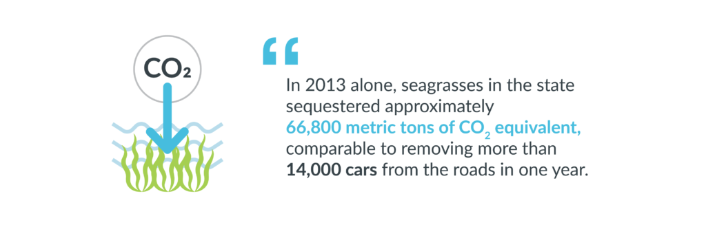
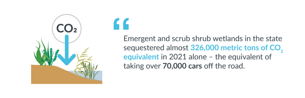
Though our work to develop the first blue carbon inventory for the period 1990-2021 will continue through early 2023, we have an initial set of findings for seagrasses that demonstrate their importance as a blue carbon habitat: in 2013 alone, seagrasses in the state sequestered approximately 66,800 metric tons of carbon dioxide equivalent, comparable to removing more than 14,000 cars from the roads in one year. Unfortunately, the inventory also shows that seagrass habitats are on the decline, with slight decreases in GHG removals taking place over the years. In addition, emergent and scrub shrub wetlands in the state sequestered almost 326,000 metric tons of carbon dioxide equivalent in 2021 alone – the equivalent of taking over 70,000 cars off the road. Collectively, these coastal wetlands store 48.8 million metric tons of carbon, showing how important it is to maintain the health of these habitats to keep blue carbon locked in the ground and out of the atmosphere.
The blue carbon GHG inventory will help bolster North Carolina’s efforts to protect and restore coastal habitats, including specific actions called for in the CHPP to improve the health of seagrass. When finished, the inventory will provide a tool for managers to account for the blue carbon benefits of new CHPP measures to conserve and restore seagrass habitats, such as reducing threats related to poor water quality through improved land management upstream.
We plan to release an interim update of initial findings, methodologies, and next steps for North Carolina’s Coastal Wetlands GHG Inventory by the end of 2022. In 2023, we will incorporate new seagrass mapping data, which will improve understanding of coastal wetland extent and how these habitats have changed over the inventory period (1990-2021). The North Carolina Department of Environmental Quality plans to integrate the blue carbon inventory into the state’s next sector-wide GHG inventory update in January 2024. Once this happens, North Carolina will be the first state in the nation to account for seagrass in its GHG inventory, setting an example for other states to inventory their own seagrass ecosystems.
The process by which the workgroup developed the first GHG inventory for seagrass in the US can provide a model for other states to estimate the carbon value of their seagrass habitats. Throughout development of the inventory, the workgroup operated by the motto “don’t let perfect become the enemy of good.” This means that entry points exist for states to begin developing GHG inventories, even in the absence of perfect data, by incorporating expert input and learning by doing.
I have been inspired by the time and dedication of all the people involved in this effort to help North Carolina develop its first blue carbon inventory. We have had researchers up and down the coast, from Maine to Florida, share their knowledge and provide advice. We still have a lot of work to do, but I know we’ll continue to make progress to better understand and leverage the blue carbon benefits of our coastal habitats.
Nature-Based Solutions for Climate Resilience: The Lightning Point project serves as a model for nature-based solutions to climate impacts, demonstrating how coastal communities can be protected and enhanced through investments in natural infrastructure. With increasing recognition of the effectiveness of such approaches, there are opportunities for broader implementation supported by recent legislation and initiatives aimed at coastline restoration and climate resilience.
Economic and Ecosystem Benefits: The restoration project demonstrated significant economic and ecosystem benefits, with a triple return on investment over 25 years. By enhancing tidal marsh and scrub-shrub habitats, the project not only provided valuable ecosystem services but also boosted eco-tourism and recreational opportunities, contributing to the local economy and quality of life.
Adaptive Management and Resilience: With a design life of 25 years, the project was built to adapt to changing environmental conditions, including sea level rise and storm impacts. The incorporation of adaptable features such as breakwaters designed to capture sediments and the development of a long-term sustainability plan highlighted the importance of resilience and adaptive management in coastal restoration projects.
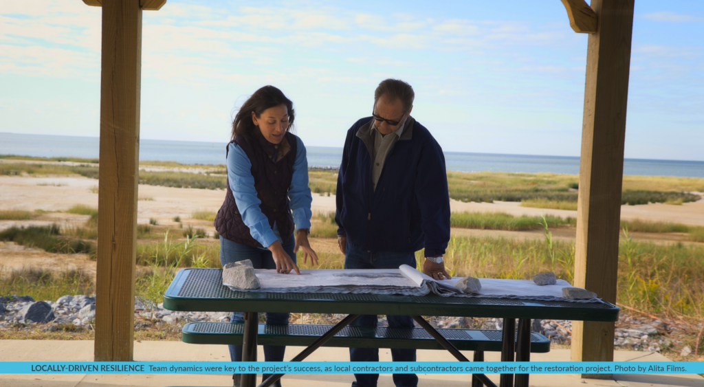
Community Engagement and Collaboration: The success of the Lightning Point Shoreline Restoration Project was heavily reliant on collaboration between various entities including local government, NGOs, private sectors, and the community itself. This engagement ensured that the project was understood and embraced by the local community, highlighting the importance of involving stakeholders in restoration efforts.
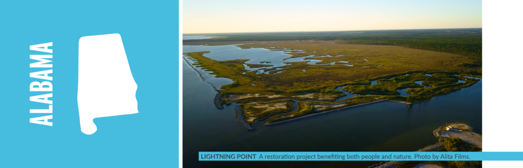
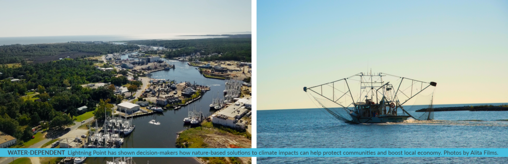
Shoreline Restoration to Protect a Coastal Community
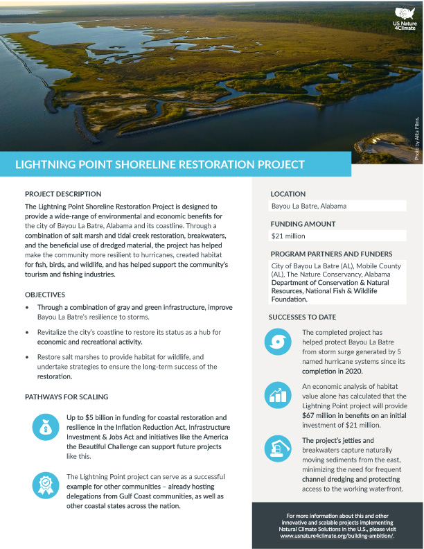
In partnership with City of Bayou La Batre, Alabama Department of Conservation and Natural Resources, Mobile County, and National Fish and Wildlife Foundation, The Nature Conservancy’s Lightning Point Shoreline Restoration Project aimed to create diverse habitats to support a wide range of fish, shellfish, birds, and other wildlife, while protecting this locally important waterfront area of this iconic town for fishing community culture. For a decade prior to the Lightning Point project, The Nature Conservancy completed a number of small-scale restoration projects, monitoring them beyond the time frame required to understand restoration techniques and outcomes. This knowledge and experience was applied to the Lightning Point project, along with a hefty dose of community engagement to understand and embrace the project.
Lightning Point in Bayou La Batre, Alabama has been exposed to coastal storms and hurricanes for more than a century. The 14-month design and engineering phase for the Lightning Point Shoreline Restoration Project began with the site being impacted by Category 1 Hurricane Nate in October 2017 losing more than 30 feet of shoreline and emphasizing the need for restoration.
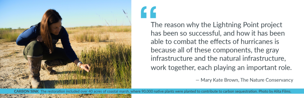
Project designs completed by Moffatt and Nichol included over 1 mile of overlapping, segmented breakwaters and jetties, 2 miles of tidal creeks, and about 40 acres of habitat: 35 acres intertidal marsh habitats and 5 acres of scrub-shrub, plus 1 acre of recycled oyster shell hash from Alabama Coastal Foundation was added as a layer for diamondback terrapin and shorebird habitat. Overall, a heterogeneous habitat mimicking nearby natural coastal marshes and barrier islands was constructed over 8 months beneficially using more than 303,000 cubic yards of dredged material – enough to fill 25,289 dump trucks – from nearby borrow sites including former upland USACE disposal area decommissioned in the 1980s and now owned by the Forever Wild Land Trust.
Performance and Impact of the Shoreline Restoration Project
Construction by Gulf Equipment Corporation (GEC) began in late fall 2019 and completed in July 2020 just in time for the 2020 hurricane season with 8 significant Gulf of Mexico tropical systems, where 4 systems produced storm surges from 3.3 feet to 7.9 feet, with a maximum of more than 11 feet once the impact of waves is taken into account. The project performed successfully in its first storm season as the new defender of Bayou La Batre with minimal erosion across the new habitats and breakwaters. Now almost four years post construction, the project has buffered Bayou la Batre from five named storms, protecting the shoreline, working waterfront, and minimizing impacts to the community and businesses.
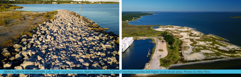
Innovative Hybrid Shoreline Restoration: Blending ‘Gray’ and ‘Green’ Techniques for Shoreline Stability and Biodiversity
The culturally and ecologically significant Lightning Point shoreline was restored with a combination of “gray” and “green” restoration methods. “Gray” articulating concrete mattresses were used along the steep shoreline, helping to stabilize eroding soils as well as the stone breakwaters that act as the first barrier to wave protection before the storm surge hits the green features. The “green” newly created intertidal marshes and higher scrub-shrub areas welcome various resident and migratory shore and wading birds, fish and shellfish, and other wildlife species. Immediate colonization during project construction by oyster catchers, black skimmers, and nesting least terns is a testament to the ecologically sensitive nature of the design and the environmental benefits for the region. In addition, the “green” features across a 600-foot swath helps buffer the wave action and storm surge before it affects the community’s amenities.
Economic Value and Adaptability of the Shoreline Restoration Project
To assess the overall ecosystem and economic values of the Lightning Point Restoration Project, we compared the $22.5 million initial construction investment to the value provided by the newly created tidal marsh and scrub-shrub habitats over the next 25 years. Totaling nearly $67 million, the project produces a triple return on investment, even without accounting for the additional benefits added by enhancing bird habitats and increasing recreational opportunities for visitors. Additionally, the region’s recent exposure to storms and storm surges shows that it can significantly help reduce the impacts of coastal storms on local Gulf communities and sustain their livelihoods.
With a 25-year design life, the breakwaters were constructed using over 56,000 tons of the largest allowable rock – with a diameter of 2-3 feet – which helps to control the project cost. Additionally, as sea levels rise, the project can be adapted to the changing conditions by adding a layer of rock to increase the breakwater height, thus sustaining the initial $22.5 million investment.
The jetties and breakwaters were designed to capture naturally moving sediments from the east, minimizing the need for frequent channel dredging of the Bayou La Batre channel, and protecting access to the working waterfront, home to the busiest seafood processors along the Gulf of Mexico. To guide future adaptive management strategies, a long-term site sustainability plan was developed for the project. This plan highlights the need to add thin layers of dredged from nearby areas across the marsh to add much needed sediment to the system, essentially feeding the marsh from the inside out. This adaptation will help offset climate impacts from sea level rise and subsidence that would otherwise drown the natural and restored marshes.
Beyond the environmental benefits, project team dynamics was key to the project’s ultimate success. The prime contractor (GEC) and most of its subcontractors are local to the Bayou La Batre region. Their care and passion for the final product was evident throughout the entire construction as they worked with the local construction industry to improve the practice of innovative coastal restoration projects and contributed to the local economy of Bayou La Batre. Significant partnerships across the local, state, federal, NGO and private sectors bloomed with the common goal of advancing the practice for resilient designs of future shoreline restoration projects to benefit the local community and current habitats.
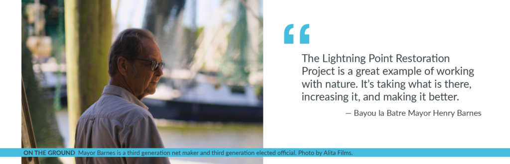
Bayou La Batre’s vibrant, water-dependent community utilizes Lightning Point for fishing, boating, and recreation. The project improved the environmental value of their shoreline areas and provided a renewed draw for eco-tourism and recreational access to the shore. “People go down to Lightning Point all the time, said Mayor Barnes. “Just about any time of the day you ride through there, someone’s either up at the pavilion or down at the fish platform or just sitting there watching the wildlife.” Local entities, including Alabama Power and Partners for Environmental Progress – Mobile, contributed to the community waterfront porch’s improvements by funding trails, pavilions, and benches to be more enjoyable by those living, working and visiting the Bayou La Batre region and beyond.
Unifying Forces: How Community Collaboration Drove Shoreline Restoration Success
Lightning Point Restoration Project is unique with its partnerships, designs, and connections. Numerous organizations, including local governments, academia, local high school, private corporations, and a wide array of non-profits, were engaged throughout the design and construction process. The project provides a nature-based restoration site accessible for these groups to observe nature-based solutions to climate impacts in action.
The Nature Conservancy engaged with Dauphin Island Sea Lab and Alma Bryant High School to contribute to the project by harvesting on-site seeds from native marsh plants in November 2019 and replanting the propagated plants in 2021. This project supported a master’s student’s research on marine debris components collected from the project site and catalogued to understand the marine debris impact on coastal habitats. It is being used to field test oysters exposed in the lab to predator cues to help strengthen their shells. And utilization of tidal creeks, breakwater edges, and marshes by different life stages of recreationally and commercially important fish using acoustic monitoring is underway. The restoration site serves as a research platform for additive adaptation measures, restoration uses, and long-term management techniques that can be applied to restoration projects throughout the Gulf of Mexico region.
Conclusion: Investing in Resilience with Natural Climate Solutions
What is the difference between Natural Climate Solutions and Nature-Based Solutions?
Nature-Based Solutions are actions that can be taken to protect and manage land and ecosystems that benefit society. Natural Climate Solutions refers specifically to Nature-Based Solutions that help address climate change. Both terms are frequently used when describing these strategies.
Lightning Point has served as a backdrop for elected officials and decision-makers to see how nature-based solutions to climate impacts can help protect communities. Local, regional, national, and international visitors have seen how the project has helped protect and boost the local community in Bayou La Batre, and are looking at ways to implement this type of project for their own backyards.
The Nature Conservancy’s Mary Kate Brown noted the win-win benefit of projects like Lightning Point – “It’s so important to invest funds in nature-based solutions for small coastal communities across the Gulf of Mexico to help address climate change, while saving billions of dollars in the future and protecting livelihoods for the long-term.” With recent legislation enacted through the Infrastructure Investment and Jobs Act, Inflation Reduction Act, and initiatives like the America the Beautiful Challenge, which together include up to $5 billion that can help support coastline restoration, the time is right for implementation of nature-based solutions across a broader landscape. There are multiple opportunities available for investments that use nature to protect and boost communities and businesses, and that if managed effectively can be constructed with an eye to adaptation for climate impacts, like Lightning Point.
Judy Haner is the Marine Programs Director for The Nature Conservancy in Alabama. Learn more about the Lightning Point Shoreline Restoration Project here.
We all enjoy telling stories around a campfire, but what if that campfire was also a tool to improve timber practices and reduce carbon emissions? The Lands Council partnered with the Kalispel Tribe of Indians and others on a pilot project to reduce forest fuels and transform them to beneficial biochar. These pilot burns were a chance for the forest community to come together and look at the many potentials for biochar on the landscape along with some of the limitations to large scale implementation.
Biochar is created in a process called pyrolysis, a high heat low oxygen environment. Many different materials, or feedstocks, from wood to straw can be used and the end product is light weight, extremely porous, and has high carbon content. Compared to the original feedstock, the carbon in biochar will last for hundreds to thousands of years in the soil. This sequestering of carbon back into the soil can offset some of the traditional practices in timber management including the use of machinery and emissions released from burning timber waste.
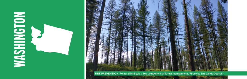
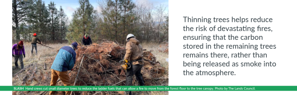
Forest thinning is a key component of forest management, particularly for wildland fire fuels reduction. Due to over a hundred years of fire suppression and aggressive logging practices, our western forests are choked with many small, non-commercially viable trees that increase the risk of catastrophic fire. Thinning these trees helps reduce the risk of devastating fires, ensuring that the carbon stored in the remaining trees remains there, rather than being released as smoke into the atmosphere. The focus of many of these thinning projects is in the WUI or Wildland Urban Interface. These are areas near houses and population centers where an uncontrolled fire can have costly and sometimes deadly consequences.
The common practice for fuels reduction thinning is to have hand crew cut small diameter trees to reduce the ladder fuels that can allow a fire to move from the forest floor to the tree canopy. These small trees and branches, also known as slash, are then stacked in piles where they are allowed to dry before they are burned in the cooler/wetter months of late fall. There are a few issues with this method of removing fuels from the forest. Burning many slash piles at once produces a lot of smoke that can impact local air quality. The burning of these piles also scorches the surrounding soils, essentially sterilizing them. The end product of burning these piles is ash which can change the chemical properties of the soil and has limited beneficial effects.
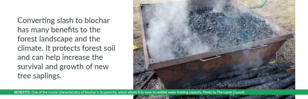
In contrast, the conversion of slash to biochar has many benefits to the forest landscape and the climate. Amending agricultural soils with biochar created from available agricultural and forest waste could sequester up to 95 million metric tons of cardon dioxide if adopted nationwide. One of the crucial characteristics of biochar is the porosity, or the numerous minute holes which allows biochar to have incredible water holding capacity. In forests, biochar can help decommission logging decks and roads, reducing soil compaction and erosion – greatly improving stream health. It can also be added to the forest floor to increase the survival and growth of saplings. Those porous holes in biochar also create habitat for beneficial soil fugus and insects. The benefits of biochar are increasingly sought after in agricultural practices from the dry land grain production of eastern Washington to the vineyards and orchards of central Washington. Producers see the benefit to their crops with increased yields and improved water holding capacity, which reduces their water needs.
Ray Entz, Director of Wildlife and Terrestrial Resources for the Kalispel Tribe, saw the value in trying out biochar burning with some recent thinning projects. “The Kalispel Tribe sees climate impacts and its effects on forestry and forest management as absolutely critical,” said Entz. “We have been witnessing climate impacts to our forests over the past 10 years or so and we are interested in making sure we are doing the absolute best we can with our management. One of the controversial areas around forestry is post-harvest biomass [referred to as slash] treatment. It has been a longstanding practice to either lop and scatter or pile and burn excess biomass post-harvest. Knowing there may be better ways to treat biomass, we offered up piles on one of our recent harvest treatments as a pilot to demonstrate the use of biochar kilns and panels to reduce biomass to a more useful product while limiting smoke and soil impacts. We worked with The Lands Council, Resource Synergy, and the WSU extension office to create the space to see and learn about biochar production. Now, we have a way to go to bring biochar to the forefront as a viable and economical practice, but this is a great start, and we are supportive of its use in the future over a greater landscape.”
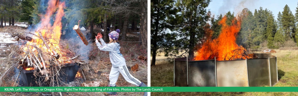
Over several crisp fall mornings, The Lands Council staff used two different techniques to convert slash piles into biochar on lands belonging to the Kalispel Tribe of Indians in Northeast Washington. The Wilson, or Oregon Kilns, are portable kilns that can be moved around the forest and operated by a team of 3-4 four. These are crossed stacked with feedstock to pack in as much wood as possible, and then each kiln is top lit. All of these steps help to reduce the amount of oxygen entering the pyrolysis process. The Polygon, or Ring of Fire kilns, are interlocking panels that can be constructed around existing slash piles and can be made to fit just about any size.
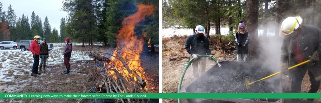
Gathered around the biochar kilns were many members of the community. Connections were made between the local public utility, which manages a biomass plant in the region, and a burgeoning biochar company that seeks to monetize the production of biochar and get it out of the forest and onto agricultural lands. We had seasoned foresters helping kids buck wood and feed it into the kilns. We had discussion with the local conservation district about creating training and a lending library for the biochar equipment so private landowners could have the valuable product of biochar while making their forest less prone to wildfires.
We also talked about some of the limitations of biochar production. These were small scale biochar productions relative to standard thinning practices that large land managers would conduct. There was also additional time and labor to cut feedstock to size and feed the kilns. We had many discussions on how to incorporate machinery to scale up and make the process more efficient. We also discussed the different market avenues for biochar, from carbon credits to landowners to selling to local hay producers. During these discussions, we established a goal of creating a circular economy through the reduction of forest fuels, using biochar as the currency. This will ultimately lead to safer forests, increased carbon sequestration, and numerous environmental benefits for the forest ecosystem.
There is still more research to be done to fully understand the climate change mitigation benefits of biochar, best practices for producing biochar and applying it to the land, and mechanisms for incentivizing the production and use of biochar. Numerous resources are available to fund this kind of research, including federal, state, and private sector support. For example, The Lands Council and Kalispel Tribe’s biochar program was supported by a grant from the Washington Department of Commerce. Federal programs like the Natural Resource Conservation Service’s (NRCS) Conservation Innovation Grants (CIG) Program can also help fund research and pilot projects. For example, a recent CIG project in Oregon supported research into different methods for producing biochar. As a result of this research, some participants in the NRCS’s Conservation Stewardship Program are allowed to convert agricultural waste into biochar.
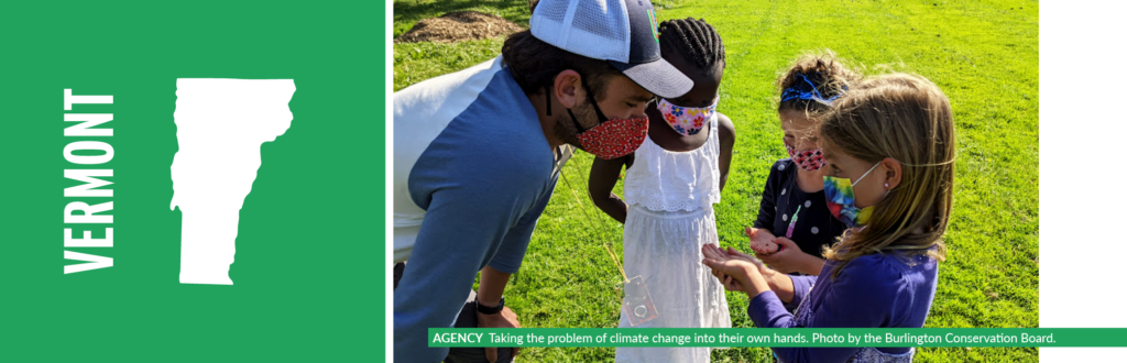
In Burlington, Vermont, packs of kids from Champlain Elementary School fan out to local parks gathering acorns, ash samaras, and birch seed. They’re taking the problem of climate action into their own hands.
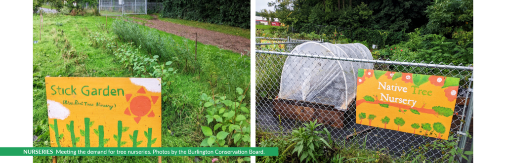
Everyone knows that trees are good for cities and good for our climate, but most cities need good locations to plant trees and sources of nursery trees for urban reforestation projects are in short supply. The solution? Simple, grow the trees yourself right on the elementary school grounds! In addition to oak, ash and birch, the children gather red osier, silk, and gray dogwood berries. This spring they also started growing trees in a “stick garden,” taking cuttings of willow, dogwood, and high bush cranberry and directly propagating them in the ground. Altogether, the students are cultivating 15 species, hundreds of individual trees and bushes—some will grow up on the school grounds and many others will be available for planting at other schools and parks.
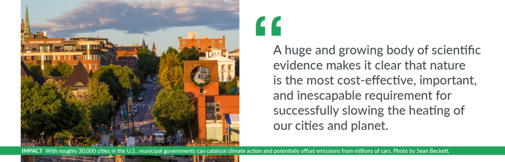
This work is happening because of the unanimous passage by Burlington’s city council of a Nature-Based Climate Solutions (NBCS) plan. A huge and growing body of scientific evidence makes it clear that nature protection is not just good for stabilizing the climate —it’s the most cost-effective, important, and inescapable requirement for successfully slowing the heating of our cities and planet. Indeed, one study revealed that we can remove an additional 18% of the nation’s current greenhouse gas emissions, just by restoring and responsibly managing our forests, farms, ranches, grasslands, and wetlands.
The plan has opened the way for numerous parts of the city government and local non-profit organizations to work together, supporting practical, inclusive actions such as growing much-needed trees while allowing children, from across a racial and socioeconomic spectrum, to have meaningful nature connection and agency around climate action. Of course these hard-working kids have some help—a partnership between Burlington’s school district, the city’s parks department, the Intervale Center (a local non-profit), Burlington Wildways partners, and the Grow Wild initiative is helping to make their tree nursery possible.
The partnership has allowed the tree project to thrive and no one partner could do the work alone. The city’s parks department waters trees over the summer, and provides supplies—while working with the school district’s grounds and maintenance staff to make sure that plans are workable. And, when many of the tree seeds failed in the first season, staff from the Intervale Center, which runs a conservation nursery, stepped in to troubleshoot and teach students and their teachers how to properly collect and start seeds of a variety of local and native species.
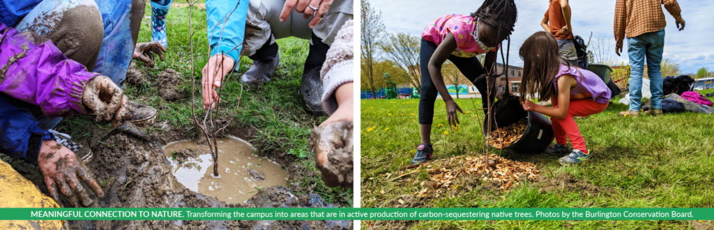
The campus of the school has transformed from a large, mowed grass lot to areas that are in active production of carbon-sequestering native trees. Students also started a wildlife corridor using their campus to connect nearby woods that grow on one edge of the school to a small patch of forest on the other side of the school grounds.
Plus, trees growing in the campus nursery will be transplanted this fall for stream-bank restoration work on an impaired polluted stream that runs along the edge of the school campus before it empties into nearby Lake Champlain. Importantly, these trees are adapted to their place; they have local genetics and were not grown in pots with fertilizer before being trucked halfway across the country. The only transportation needed: strong arms and legs.
This tree work happening at Champlain Elementary School is just one of many areas where Burlington’s Nature-based Climate Solutions Plan aims to have an impact. The NBCS plan is organized into six theme areas: urban forests and tree canopies; water and wetlands; lawns, fields, and small open spaces; agriculture and community gardens; green infrastructure; and an overarching theme of equity, inclusion, and relationships. Burlington’s NBCS plan includes an implementation matrix that emphasizes the importance of community and departmental collaboration to achieve the city’s new climate mitigation, adaptation, and equity goals.
Now the city’s overall climate action efforts can be supported not only through its bold and ambitious Net Zero Energy Roadmap but also through its commitment to natural climate solutions.
With help from these partners and the NBCS plan, leaders in Burlington have started to quantify some of the benefits of the city’s natural assets and plan for the future. For example, according to American Forests’ Tree Equity Score tool, the urban tree canopy across the city stands at 42%. A recent analysis of the city’s tree canopy, using iTree Software, reveals that these trees sequester enough carbon to equal the removal of 450 cars from the road for a year, and these benefits will increase as the canopy increases. Additionally, the canopy is able to remove 26,500 pounds of air pollutants and avoid 43 million gallons of stormwater runoff each year, collectively reducing health incidences for residents and creating a healthier natural environment.
Trees excel at reducing the urban heat island effect, extreme heat mortality, and heat stress. An upcoming urban forest plan for Burlington will start to quantify the benefits of urban cooling provided by the canopy. The city aims to increase tree canopy, with a focus on tree equity. Areas of the city with the least coverage by tree canopy have the highest priority for tree plantings. And with support from the Arbor Day Foundation, a surge in tree plantings took place over the past three years across three city wards. The project focused on planting trees on streets with no greenbelt and in city parks with low shade cover, utilizing large planters to increase tree survival. Over the past three years, this project has planted 360 trees.
There are many more ways that nature-based climate action is at work in Burlington including: extensive regenerative agriculture and community gardening programs; backyard and park native habitat restoration; additional urban tree nurseries beyond the new one at Champlain Elementary; an advanced street tree program; riparian and wetland restoration and regeneration work; neighborhood-based food forests; invasive species removal and pollinator habitat enhancements.
Behind this work can be found a unique mix of nonprofits, an innovative school district, and two local government park entities working side-by-side—all working together to secure the city’s “triple bottom line” of social, economic and ecological thriving in Burlington, in the face of dramatically warming temperatures.
As Burlington embraces nature-based solutions, city leaders are creating a future prioritizing the safety and health of both people and the environment in the face of climate change. Burlington’s Nature-based Climate Solutions Plan serves as an example for municipalities across the country that are interested in tackling local impacts of climate change. With approximately 30,000 incorporated cities in the United States, city governments are a catalyst for continued climate action — with the potential to offset emissions from millions of cars; provide local cooling through evapotranspiration under the shade of trees and urban forests; and giving the next generation tools, motivation, and hope for a livable and bright future.
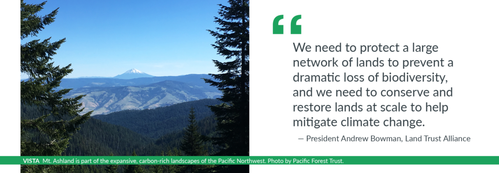
“When I got up to the crest along the trail, I had amazing vistas of forests rolling along the ridges for miles south to Mount Shasta in California and north to Mount McLoughlin in Oregon,” Connie Best remembers. “It really struck me that we will never heal our climate without amping up the power of these forests to capture excess carbon from the atmosphere and lock it up for a long time. It is so critical to sustain healthy, resilient forests so they can help save us from climate catastrophe.”
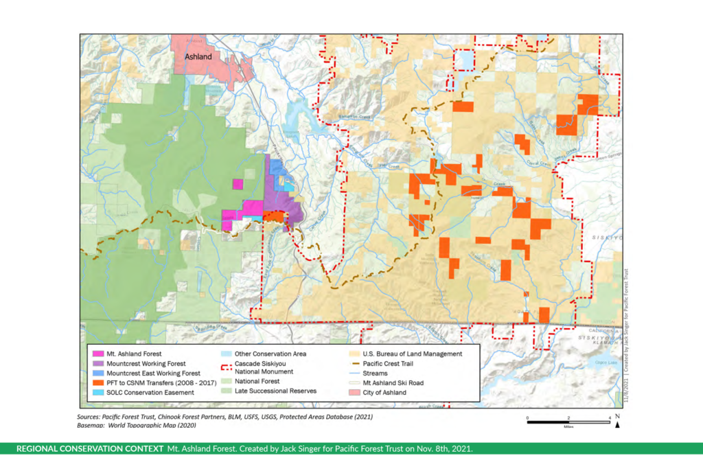
Connie, the Pacific Forest Trust’s (PFT) co-founder, has been working with private and public partners for 18 years to secure the conservation Southern Oregon’s forests – the most biodiverse forest on earth. This huge landscape, situated at the junction of the Cascade and the Siskiyou mountains along the divide between the Rogue River and Klamath River basins, supports more species of conifers than anywhere else in the world. That diversity — and an array of rare plants — is why the Cascade-Siskiyou area has been designated an Area of Global Botanical Significance according to the International Union for Conservation of Nature, an organization dedicated to protecting biodiversity. With rugged topography, unique soils, abundant water, and corridors for wildlife migration in every direction, the region, which includes the Cascade-Siskiyou National Monument, is a critical stronghold for biodiversity as climate change accelerates.
Having conserved more than 10,000 acres in this region, mostly within the Cascade-Siskiyou National Monument, PFT is now on the verge of purchasing 1,120 acres along the Siskiyou Crest, just west of Interstate 5 and a short ride from the beautiful town of Ashland, Oregon. This is the largest unprotected, privately-owned forest property at the headwaters of Neil Creek, a major tributary to the Rogue River. PFT will be actively managing the Mount Ashland Demonstration Forest as a model of how forestry focused on enhancing climate benefits can meet the moment for people and wildlife.
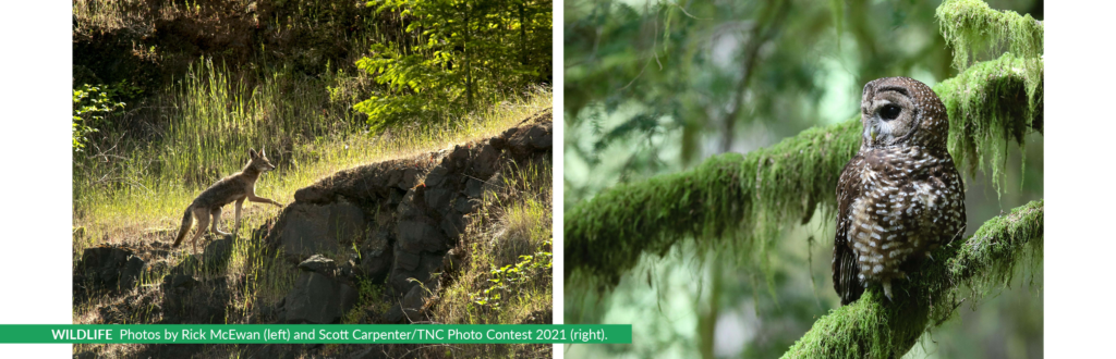
We call the property a “super-wildway,” connecting the Cascade-Siskiyou National Monument with the Rogue River-Siskiyou National Forest. It neighbors other forest properties conserved by private landowners with assistance from PFT, creating a nexus of private-public lands managed for imperiled species and biodiversity. Such large, intact landscapes are critical to climate resilience. Threatened wolves, Pacific fisher, marten, and birds like the northern spotted owl all attest to the critical connections provided by the Mount Ashland Forest.
We can see that the climate in which these forests originally flourished has already changed — and the forests are changing, too, as the region is already hotter and drier. It is critical to act now to protect the treasure-house of biodiversity and forest carbon in the Cascade-Siskiyou region. After 100 years of fire suppression, loss of Indigenous management and a focus on commercial wood production, we urgently need to put the best science to work to help sustain this refuge. Every acre of this forest land has more than 100 tons of carbon dioxide stored in its trees — and can add tons more each year with careful management.
PFT is excited to meet the challenge of restoring fire-adapted habitats and protecting forest carbon. With the advice of a team of forest scientists and tribal cultural practitioners, our management will enhance habitats to improve adaptation options for plants and wildlife, restore more resilient forest structure, improve forest health, reduce the threat of catastrophic fire, and increase lasting carbon stores. Our strategy will focus on reducing the density of small trees, conserving, and restoring the dominance of older, larger trees, creating more variety in spacing of the trees so fire can’t spread as easily, and enhancing the property’s significant spring-fed wetlands and stream-side hardwoods.
This is just one example of the powerful role that non-profit land trusts can play in helping America’s forests and grasslands adapt to climate change, while simultaneously protecting the carbon already stored on our landscapes. Land trusts are poised to use nature to slow climate change, while also helping nature itself adapt. Research indicates that approximately 21 percent of the reductions needed in the United States can occur through “natural climate solutions” — in other words, by working with nature.
PFT’s acquisition of the Mount Ashland Forest is supported by grants from the Oregon Watershed Enhancement Board — funded through lottery proceeds — and the Land Trust Alliance, a national nonprofit working to save land, strengthen communities, and create a healthier planet by supporting land trusts. The Alliance recognizes, as President Andrew Bowman has noted, that “we need to protect a large network of lands to prevent a dramatic loss of biodiversity, and we need to conserve and restore lands at scale to help mitigate climate change.”
To advance this work in the carbon-rich landscapes of the Pacific Northwest, the Alliance partnered with charitable foundations to launch the Pacific Northwest Resilient Landscapes Initiative. The Initiative funds land trust projects that help build and secure this network. PFT’s Mount Ashland Forest fits these goals perfectly, supporting durable carbon storage while stitching together a vital wildlife corridor.
Land purchases like the Mount Ashland Forest project, and tools like conservation easements that pay private landowners to keep their properties intact and adopt conservation practices, already play a crucial role in both protecting biodiversity and addressing climate change. And they are poised to play an even bigger role moving forward, with $2.1 billion dollars dedicated in the Inflation Reduction Act to the Forest Legacy Program and Agricultural Conservation Easement Program. These programs will help more landowners access financial assistance to keep farms and woodlands intact and manage them for climate benefits.
Connie is thrilled to see this project finally come together after years of work — and not a moment too soon. “When I am hiking through this beautiful place, I am amazed at the biodiversity — and fearful of its loss,” said Connie. “Time is of the essence. It is so important to put the insights from Indigenous traditions and top scientists into action. PFT will work across boundaries with our public and private neighbors, and share lessons with the larger community so our work can advance climate resilience across this special region. The forests do so much for us — now we must help them.”
Owen Wozniak is Land Transactions Program Manager at the Land Trust Alliance.
About Pacific Forest Trust
Since its founding in 1993, the conservation and restoration of private working forests has been at the core of Pacific Forest Trust’s mission to sustain America’s forests for all their public benefits of wood, water, wildlife, and people’s well-being, in cooperation with landowners and communities. PFT has protected over 250,000 acres of forest and holds conservation easements that guide management for climate benefits, wildlife adaptation and water security on over 110,000 acres in California and Oregon. Learn more about our work: www.pacificforest.org
About the Land Trust Alliance
The Land Trust Alliance works to empower and mobilize land trusts in communities across America to conserve land — and connect people to the land — for the benefit of all. As the national leader in policy, standards, education and training, the Alliance has supported land trusts for forty years. During that time, land trusts have protected over 60 million acres—more land than is in the entire national park system. To address the challenges of climate change and biodiversity loss, and to ensure nature’s benefits touch every American, the Alliance has set a bold goal for land trusts to conserve another 60 million acres by the end of the decade. Learn more: https://www.landtrustalliance.org
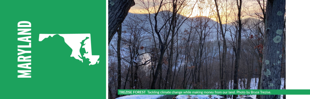
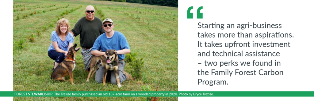
Our family has always shared a mutual love of the outdoors. When we purchased an old 187-acre farm on a wooded property in 2020, little did I know that it would ignite a journey of forest stewardship.
My dad wanted to plant and sell Christmas trees and start a vineyard, and my mom wanted to try her hand at maple syrup. Being close to my parents and the property gave me the opportunity to jump in feet first as a co-owner in this operation.
But starting an agri-business takes more than aspirations. It takes upfront investment and technical assistance – two perks we found in the Family Forest Carbon Program.
We got into forest management by carving out trails and cutting fire breaks, but our knowledge of forestry was introductory at best. So, we reached out to the Maryland Department of Natural Resources and connected with a forester who helped us verbalize our visions for the property and craft a forest management plan. I was proud to be a part of this exercise. My family cares about being good stewards, supporting wildlife, and we want our property to be something that contributes to a larger cause like climate change.
Over the next two years, we planted 600 Christmas trees and nearly 500 grapevines for wine in a 30-acre field. Our goal is to plant Christmas trees that can be harvested once every eight years and to tend to about 1,500 grapevines, in addition to producing maple syrup from our forests. But we are just getting started.
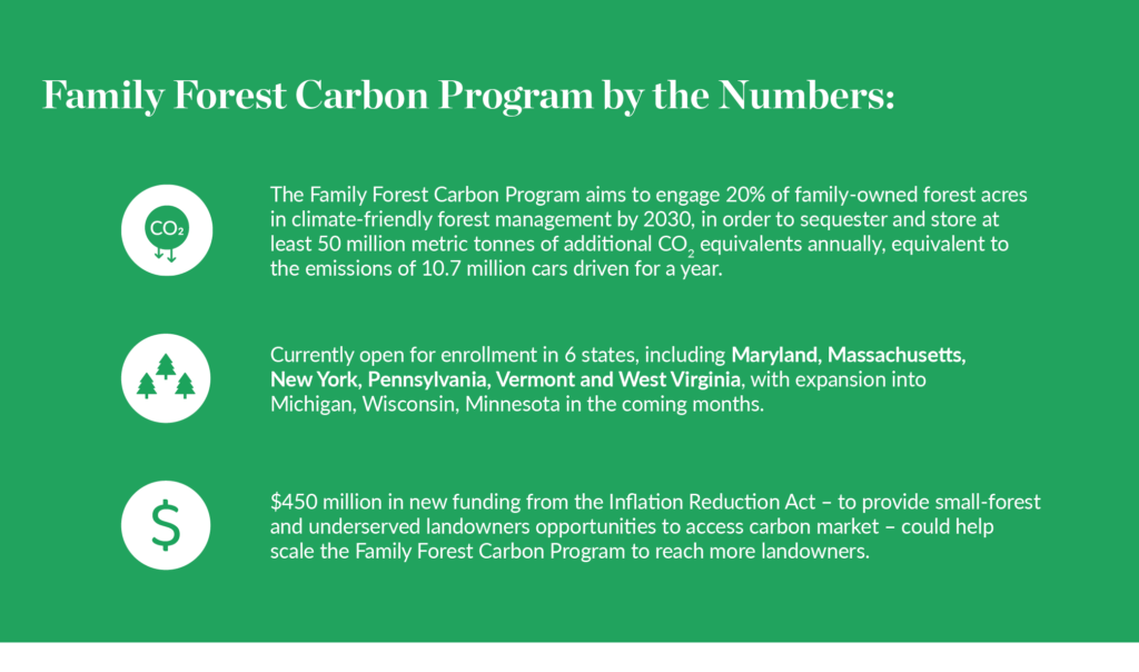
An agri-business like this needs upfront cash with delayed revenue streams, even as we were maintaining and expanding our projects on the property. We needed to explore other ways to generate revenue that we could use to put into the land. Our forester told us about the Family Forest Carbon Program. The Program is a carbon program uniquely designed for owners of small, forested properties. It was developed and is being implemented by the American Forest Foundation (AFF) and The Nature Conservancy (TNC).
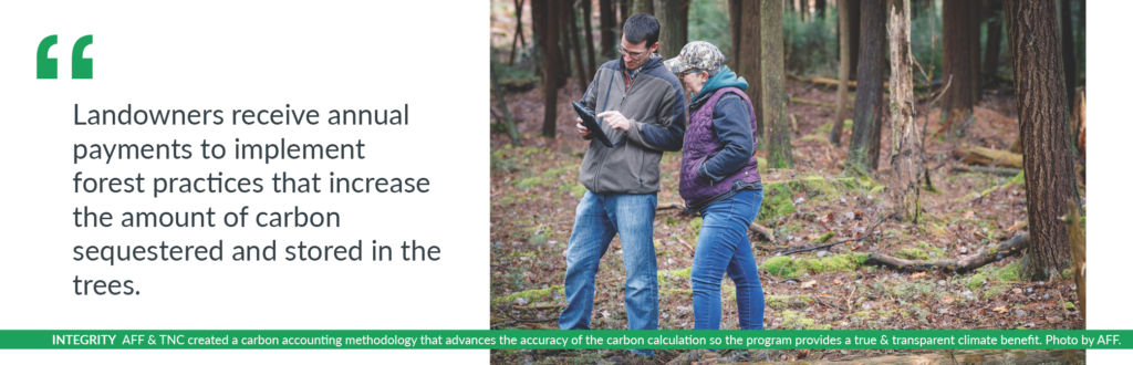
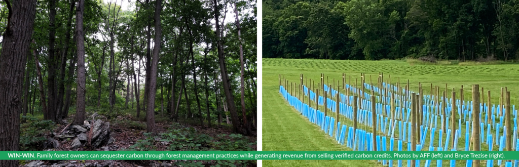
The Family Forest Carbon Program addresses climate change by supporting landowners in caring for their forests to make them healthier and more productive. Landowners receive annual payments to implement forest practices that increase the amount of carbon sequestered and stored in the trees. These practices also create needed habitat for bird and wildlife species. Participants can still conduct harvests, as long as they are in line with sustainable harvesting requirements. The program also offers a chance for participants to connect with a forester and other resources needed to adopt long-term sustainable management.
We were impressed with the program’s dedication to integrity. AFF and TNC have created an innovative new carbon accounting methodology, that is approved by Verra’s Verified Carbon Standard. This new methodology aims to enhance accuracy and transparency to ensure the program is providing a true climate benefit.
We decided to enroll. Our agri-business is not just about the vineyard – it’s about being good stewards of the land and conservation. I hope more landowners are able to connect with market-based opportunities like this that help them fulfill their personal goals too.
The Family Forest Carbon Program is in the process of scaling to more states. The Program has established itself in Pennsylvania, West Virginia and Maryland, enrolling more than 220 small forest holders, who collectively own more than 35,000 acres. Thanks to recent funding from the Inflation Reduction Act, carbon markets for small forest holders are getting a jumpstart, but they will need more partners and backers like the state of Maryland and continued support from the federal government to bring the program to landowners.
As a technology consultant, I think about owning land as a business. Caring for our forests and making them healthier requires investments in time and money, but they are also investments in our planet. The benefits forests produce – clean water, habitat, carbon sequestration and storage –are larger public benefits. Our small piece of nature is incredibly valuable to us, but even more so when one considers the difference we can make from our corner of the world. I hope other citizens and our leaders see opportunities like this and continue to expand the options available to unlock what’s possible across our private forestlands.
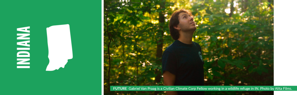
“Eventually, climate change will affect all of us, because climate change doesn’t discriminate. We need to prepare ecosystems. A call to action that is not only driven by our personal gain, but more so for providing a sustainable future for generations to come.”
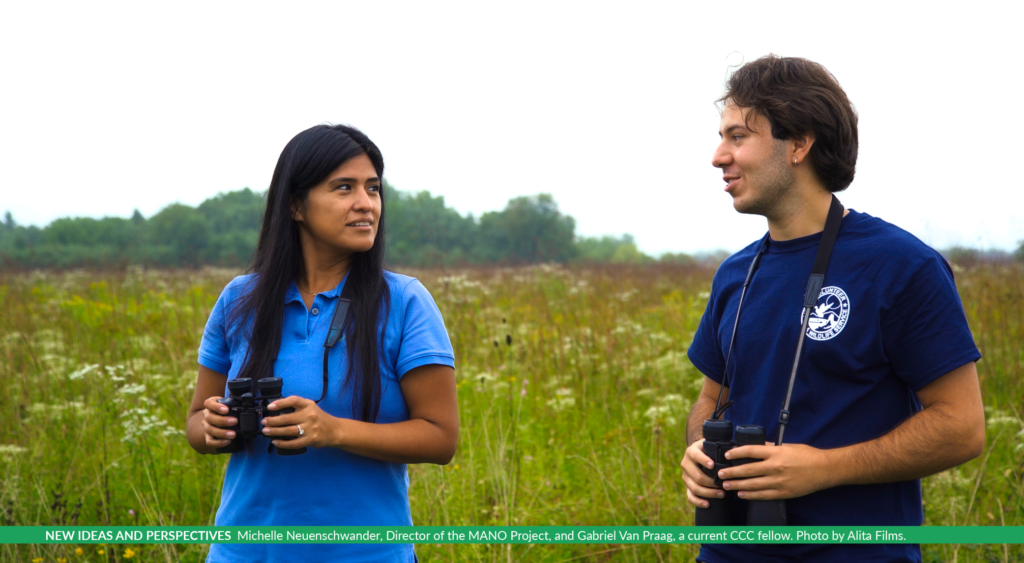
Gabriel Van Praag, Civilian Climate Corp Fellow, MANO Project
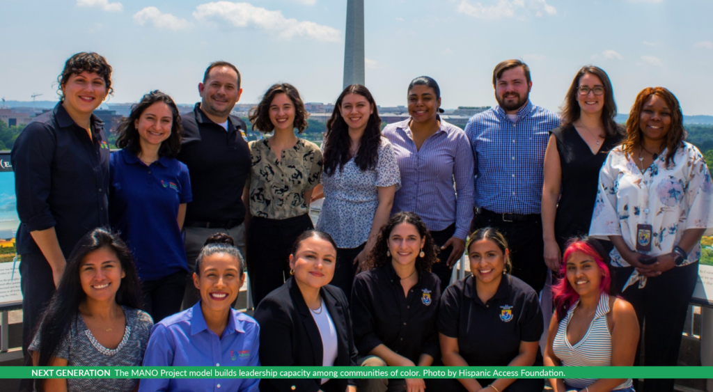
Impassioned for change, in 2010 Maite Arce created the 501(c)(3) non-profit Hispanic Access Foundation. With a clear vision, her motive was to unite her community and their environmental interests in hopes of creating a more equitable society. Meanwhile, the U.S. Census estimates that the Hispanic population will nearly double by 2050 to more than 100 million Latinos. With the knowledge of changing demographics, there is a growing need to engage the passion that young Hispanics have for environmental advocacy and conservation. As a result, Hispanic Access launched the My Access to Network Opportunities (MANO) Project. The MANO Project strives to connect and build young leaders of color to protect public lands and create equitable and just climate change strategies.
The MANO Project’s model builds leadership capacity among communities of color and the nation as a whole. We do so by building trusting relationships with organizations and federal agencies to provide professional development and training opportunities for college students and graduates. Our current partnerships include: the Bureau of Reclamation, Colorado Parks and Wildlife, National Park Service, U.S. Fish and Wildlife Service, and the U.S. Forest Service. A special feature of the MANO Project is that all internships are paid, allowing low-income individuals the opportunity to enjoy a leg up in their careers they otherwise could not afford. In the words of Fernando Lara, a first-generation college student who worked his way through school, “Before learning about the MANO Project, I saw similar internships. However, they were unpaid, and I couldn’t participate because I wouldn’t have had time to do the internship, work, and still go to school. Thankfully, MANO’s paid internship paved the way for me to get into a field I’m passionate about without the burden of wondering if I was going to be able to pay the rent.”
In addition to advocating for positions with liveable wages, the MANO Project administers a comprehensive framework to support workforce functions where current federal workforces fall short. This includes promoting a pathway of access for minority students and recent graduates to participate in an equitable recruitment and selection process. Once program hours have been completed, many interns qualify for certificates that offer a Direct Hiring Authority (DHA) status. This status opens up access to full-time employment within the federal government, helping America reach climate goals with a stronger, more diverse workforce. To date, more than 450 alumni have participated in our various internship programs. Most recently, the MANO Project has partnered with the U.S. Fish and Wildlife in 2021 to debut the Civilian Climate Corps Fellowship Program (CCC), the first of its kind in providing young professionals an opportunity to be on the leading edge of the climate change fight by aiding the National Wildlife Refuge System’s (NWRS) response to climate mitigation and adaptation. These strategies will yield high impacts, such as ensuring that carbon already sequestered in our National Wildlife Refuges remains locked in trees and other vegetation, while providing an opportunity to explore restoration activities that help draw additional carbon dioxide from the atmosphere.
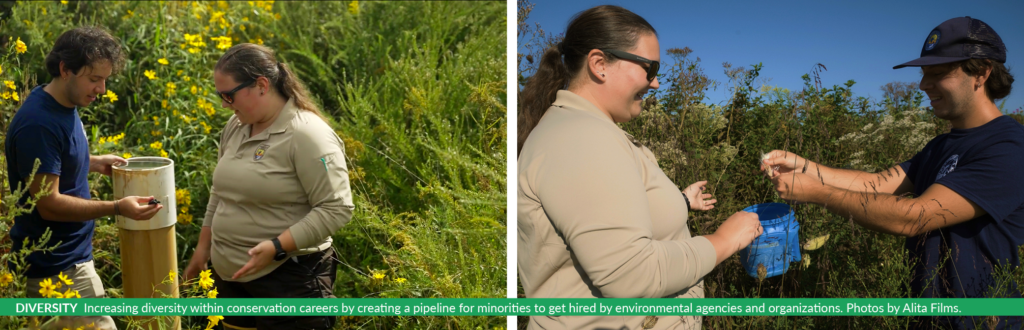
Historically, the decision-making process in the field of conservation has left minorities and vulnerable communities out of the conversation. Despite growing diversity in the United States, the racial composition of environmental institutions has remained between 12% to 16%. Currently, the demographic makeup of most U.S. environmental organizations does not reflect that of the country as a whole. The MANO Project aims to change that by increasing the representation of historically underrepresented groups within conservation careers by creating a pipeline for them to get hired by environmental agencies and organizations. We are effectively enabling opportunities for substantial professional development within diverse cultural resource projects for students of color who not only overwhelmingly support the preservation of our parks and public lands, but also are capable of engaging their communities. This allows for new ideas and perspectives to become key aspects of an equitable fight against climate change.
“When we think about conservation and the environment, what first comes to mind are images of sweeping plains and mountains, untouched by people,” says Nina Marti, Program Manager for the MANO Project. “What’s missing from that narrative, and how we respond to climate and environmental crises, are the ways in which people of color have established relationships with nature; how generations of Indigenous peoples have cared for this land, how enslaved and exploited peoples have cultivated this land, and how we integrate green space into urban areas. These narratives offer insights on how we can shape our relationship with nature and the climate for the better, but we can’t learn from them or integrate them until the keepers of those stories and practices are afforded equitable opportunities in their fields.”
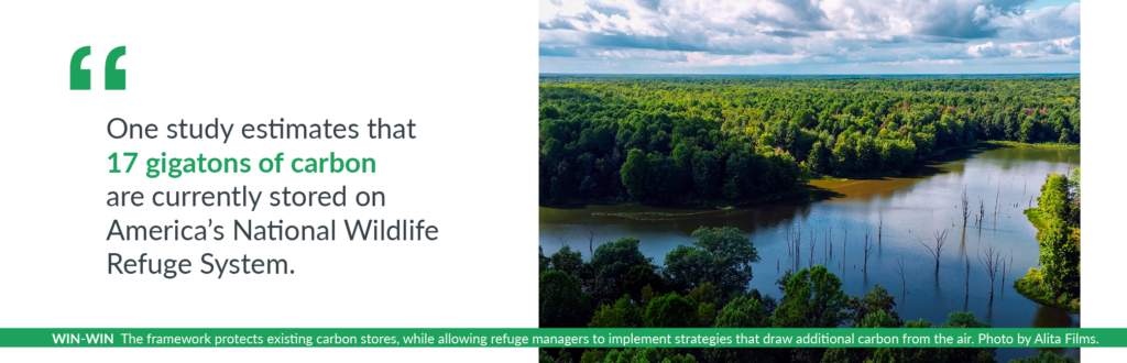
The U.S. Fish & Wildlife Service’s 2021 launch of the 18-month fellowship program for the newly reintroduced Civilian Climate Corp (CCC) program is an exciting example of how government agencies can support climate adaptation efforts. As part of President Joe Biden’s American Jobs Plan, the CCC program hired young Americans to work on combating the climate crisis within the National Wildlife Refuge System (NWRS). Such roles are crucial, as one study estimated, 17 gigatons of carbon are currently stored on America’s NWRS. By developing and refining a climate adaptation framework, which utilizes existing plans, data on climate change and other stressors, ecological transformation, and a structured decision-making process, their work informs how Refuges will address climate change. Implementing this framework is a win-win opportunity. It protects existing carbon stores, while also allowing refuge managers to implement strategies, like native vegetation plantings, that help draw additional carbon from the air.
“The NWRS is on the front-lines of climate change,” said Cynthia Martinez, Chief of the NWRS. The CCC enlists the next generation to utilize new ideas and perspectives, ensuring a sustainable future for all. The MANO Project is committed to ensuring these, and future roles remain open to communities of color. “Engaging young people in diverse communities to be at the front and center of addressing the climate crisis is one of the MANO Project’s core goals,” said Michelle Neuenschwander, Director of the MANO Project. “Our work is about the next generation of Latino leaders. This unique experience provides extensive training, mentoring and professional development to ensure students have the tools and knowledge needed to excel in their fellowship.”
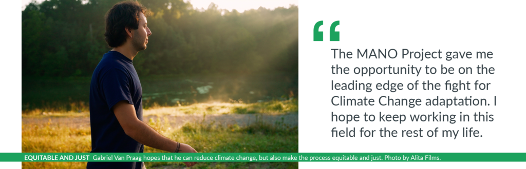
“The CCC is unique in its programming, but could be used as an example for other agencies,” says Crystal Strong, Program Associate for the MANO Project. “As needs for climate adaptation continue to take center stage, so do needs for jobs that tackle the larger issues at hand. As programs and positions are created, The MANO Project will continue to advocate for future opportunities to be accessible to diverse students and graduates. These internships and fellowships are monumental to opening pathways for full time employment within these agencies.” In the words of Gabriel Van Praag, a current CCC fellow, “The MANO Project gave me the opportunity to be on the leading edge of the fight for climate change adaptation. I hope to keep working in this field for the rest of my life. I really hope that I can reduce climate change, but also make the process equitable and just.”
In addition to the CCC, the US Forest Service (USFS) and Hispanic Access Foundation have partnered to support the next generation of conservation and environmental stewards through the Resource Assistant Program (RAP). This partnership aims to build a strong community of inspired, skilled, motivated leaders through substantial work experience and building skills required for success in natural resource careers. RAP fellows are placed at USFS national forests and offices throughout the U.S. and support the mission to care for the land and serve the people. Interns are introduced to various tasks and projects such as: lands management, conservation education, resource interpretation, and rehabilitation activities through their assignments on public lands across the country. RAP projects bring fellows in direct contact with climate impact work through assignments in fire management, forest restoration, wildfire prevention and air quality management. An inspiring example of one of our interns doing so is Valery Serrano. A first-generation Latina, Valery Serrano, is a current MANO Intern with RAP stationed at the San Juan National Forest in Colorado. Through this program, Valery is pursuing the career of her dreams by working with wildlife and assisting wilderness and fire crews in educating the public on fire safety in the National Forest.
The U.S. Office of Personnel Management (OPM), the chief human resources agency for the federal government, has made workforce data for the federal civilian workforce available through a tool called Fedscope. The most recent diversity data trends for June 2022 demonstrate ample room for growth for minority groups in Science and Engineering occupations within the federal government. In Science occupations (Natural Resource Management, Biological Sciences, Environment Protection, Soil Conservation), 26% of current employees identify as a minority, and in Engineering occupations (Environmental, Civil, Electrical, Nuclear) 28% of current employees identify as a minority. Since its creation in 2015, the MANO Project has grown from offering one program encompassing a handful of internships to about 200 interns across 17 different national programs. At this stage of growth, we would like to expand into private and NGO sectors to diversify our opportunities, broaden access to environmental careers, and influence the field beyond the government sector. The MANO Project will continue to support programs like CCC and RAP that specifically work to target climate mitigation and adaptation. We will continue to encourage climate mitigation organizations to allocate resources to diversifying their own workforces so as to create meaningful dialogue around and solutions to climate crises.
Learn more about Hispanic Access Foundation, the MANO Project, and its fellowship programs at hispanicaccess.org and manoproject.org. Don’t see an internship fit? Get notified when we add new opportunities throughout the year when you sign up for alerts. For inquiries regarding partnerships, please email info@hispanicaccess.org, or fill out our inquiry form.