We live in a rapidly changing world, and with change comes uncertainty.
The growing instability of our climate – and the erratic weather patterns that come with it – have made supply chains less reliable, economic forecasts less predictable, and the security of our communities more fragile.
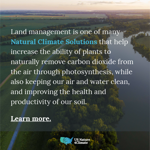
As decision makers across the country look for solutions to keep communities secure, nature can provide powerful solutions. Actions such as planting and maintaining trees, implementing sustainable agriculture practices, and restoring coastal wetlands – strategies known as nature-based solutions – can help people and economies. They safeguard clean water, preserve wildlife habitat, and support millions of jobs, all while reducing carbon pollution to create a more stable climate for the future.
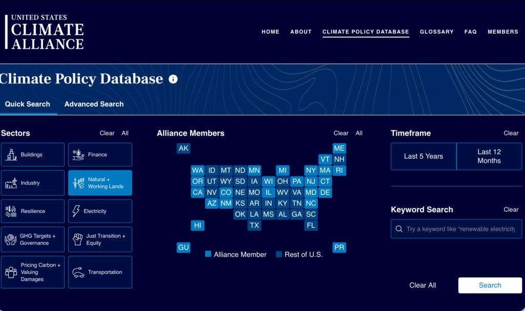
But knowing how and where to implement these solutions can often be complicated. A new online resource called Nature4Communities is now available to help legislators, community leaders, businesses, and others identify which nature-based solutions can best meet their needs during these uncertain times.
The resource provides an interactive map that identifies state-specific examples of nature-based solutions being implemented across the nation. Users can click on these projects to get a deep dive into how they were launched, their impact, and what more could be achieved with greater funding.
Users can also create customizable fact sheets for a variety of states, selecting the types of nature-based solutions they want to highlight, such as coastal restoration or reforestation. The web tool then generates graphics and scientific data on the economic, social, health, and other benefits those projects provide, along with data highlighting the overwhelmingly support among voters for funding for these solutions.
The customizable fact sheets can be used to educate Members of Congress and other decision-makers about how nature-based solutions can help their local communities and economies by creating jobs, supporting industries, and reducing the risk of costly natural disasters.
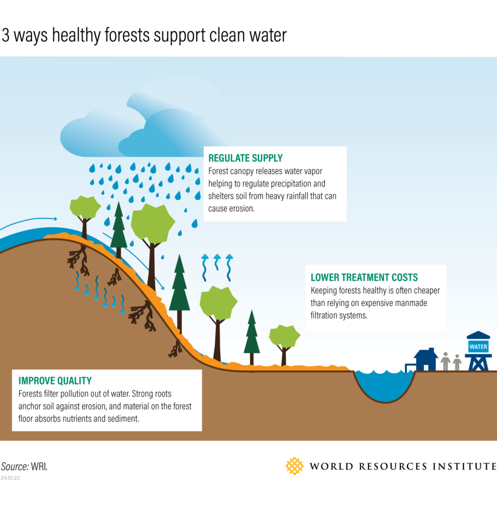
Protecting Communities and Economies with Nature-Based Solutions
Healthy lands and waters have long served as the foundation of businesses across the nation. For example, healthy coasts and waterways underpin America’s commercial and recreational fishing industries that support 2.3 million jobs and generate $321 billion in sales each year.1 America’s vast forests – which provide us with everything from building materials to paper products to medical supplies – support manufacturing businesses that employ nearly 1 million people and generate $288 billion in revenue annually, equal to about 4 percent of the entire U.S. manufacturing gross domestic product.2
Protecting the nation’s natural systems also can help shield communities from the growing droughts, storms, and other threats brought on by the changing climate. Coastal wetlands act as sponges that absorb flood waters and provide American communities with $23 billion in flood protection each year.3 Forests serve as natural water filtration systems, removing pollutants and regulating flows to help ensure clean and abundant drinking water in times of drought.
A study conducted in Minnesota in 2023 found that for every $1 invested in natural solutions more than $8 in public benefits is created, from disaster risk reduction and improved wildlife habitat to better air quality and healthier soils to grow cops.4
And nature-based solutions not only keep lands and waters strong, but they also have the added benefit of generating even more jobs and income. One study estimated that environmental restoration projects already account for some 221,000 jobs in the United States and generate almost $25 billion in economic output.5 But that’s just the beginning. A major campaign to plant trees across the nation could create up to 150,000 new jobs a year, triple the number of new jobs created in the oil and gas industries in 2018.
As we implement these solutions that sustain our nation’s lands and waters, we also bolster their natural ability to remove climate-changing carbon dioxide from the air, securing greater stability for generations to come. Nature-based solutions currently remove 13% of annual greenhouse gas emissions across the United States,6 equal to nearly half of all emissions created by the nation’s planes, trains, and automobiles.7
A Winning Solution
Supporting the implementation of these solutions is a winning proposition for decision-makers. A national poll conducted last year on behalf of U.S. Nature4Climate – a coalition of American businesses, conservationists, farmers, ranchers, hunters, and others – found that 94% of voters support the expansion of these natural solutions through legislation and increased public funding at the federal, state, and local levels. That support crosses party lines with 99% of Democrats, 94% of independents, and 89% of Republicans saying they want greater investments in natural solutions. The poll also found that an overwhelming majority – 69% of all voters – are more likely to have a favorable view of Members of Congress who back these solutions.
It is easy to feel uncertain during these changing times. But nature has provided security and stability across the nation and around the world throughout history.
Whether it be coastal communities searching for ways to shield themselves from growing storm surges, farmers trying to improve soils for more abundant crops, or fishing industries working to keep waterways healthy and productive, Nature4Communities offers the information decision-makers need to advance nature-based solutions and create a more secure today and tomorrow.
A new national survey conducted by U.S. Nature4Climate shows that voters across party lines support natural climate solutions more than ever, suggesting fertile ground for bi-partisan cooperation and consensus-building, opening up new avenues for climate action. Learn more.
Explore Nature4Communities, a resource that shows you how nature-based solutions are critical for your community’s well-being and become a better advocate for their implementation.
Land conservation is a critical and cost-effective climate solution that delivers significant environmental, social, and health benefits.
Protecting existing carbon-rich landscapes should be a top priority, as they offer the greatest and most immediate mitigation potential and co-benefits.
Land conservation enhances community resilience, supporting clean air, water, biodiversity, and public health, while also fighting climate change.
Real-world examples prove that land conservation works, with measurable benefits to communities and ecosystems, including carbon sequestration, water protection, and habitat restoration.
Now is the time to act on land conservation, utilizing data, tools, and community partnerships to scale up efforts in the fight against climate change. Read more below.
“Every acre conserved is more than just land; it’s a commitment to the future.” That’s the theme of a new report by the Land and People Lab at Trust for Public Land. The new report makes case that land conservation is a cost effective, high impact natural climate solution (NCS) that delivers multiple benefits at scale. The Power of Land Conservation to Address the Climate Crisis synthesizes the latest science around how conservation delivers quantifiable benefits across five distinct areas: carbon storage, water, air, biodiversity, and human health. It then lays out compelling case studies highlighting real-world conservation projects across the U.S that are delivering these benefits. And finally, it ends with a call to action:
With a clear understanding that land conservation can help protect our climate—and our communities—now is the time to act. Through meaningful engagement with communities and advocacy for increased funding and innovative policies, the conservation community can play a central role in tackling the climate crisis while building healthier, more equitable, and more resilient communities nationwide.
“The report elevates land conservation to its rightful place as a critical climate solution and calls the entire conservation community to action. With new data and tools, we have what we need. The time to act is now.”
Abigail Weinberg,Senior Director of Conservation Science & Planning at the Open Space Institute.
Quantifying the Impact: Conservation as a Climate Solution
When it comes to climate solutions, land conservation – a tradition in the U.S. that dates back to the 1800s and beyond – is often left out of the conversation. However conserved lands like forests, wetlands, and grasslands serve as vital carbon sinks. U.S. forests currently absorb nearly 13 percent of the nation’s annual greenhouse gas emissions. Across all natural landscapes, carbon storage and sequestration capacity is immense: Wetlands in the lower 48 states store over 11 billion metric tons (11 gigatons) of carbon—representing one of the highest carbon stocks as measured on a per-acre basis. Coastal ecosystems, such as tidal marshes and mangroves, can sequester carbon ten times faster than tropical rainforests; and grassland carbon is often touted as one of the most secure carbon vaults because the carbon is stored belowground where it is less vulnerable to wildfire and other natural disturbances. But these natural lands are under threat.
According to Global Forest Watch, between 2001 and 2022, the U.S. lost 113 million acres of tree cover—a 17 percent decrease. Our wetlands are also disappearing or are being degraded, and research has shown that carbon stocks are often lower in wetlands that have seen major human disturbances.
That’s why leading research by Susan Cook Patton et al. note that “counter to an emerging preference for restoration,” protecting carbon-rich landscapes should often be the top NCS priority based on “(1) the magnitude and (2) immediacy of mitigation potential, as well as (3) cost-effectiveness and (4) the co-benefits they offer.”
The Broader Impact: Air, Water, Health and Biodiversity
The benefits of land conservation extend beyond carbon sequestration. Conserved lands significantly improve air quality, with U.S. trees and forests removing 17.4 million tons of air pollution in 2010 alone—yielding health benefits valued at $6.8 billion. Additionally, around 83 million people in the U.S. rely on forested watersheds for clean drinking water. However, these water resources are increasingly threatened by urbanization and climate change.
Biodiversity is another critical area where land conservation has a measurable impact. A 2023 analysis by NatureServe, one of the leading biodiversity conservation nonprofits in North America, shows that 40 percent of animals, 34 percent of plants, and 40 percent of ecosystems nationwide are at risk. It further noted that land conversion is a major determinant of the numbers of U.S. species and ecosystems at risk, with grasslands and wetlands being most affected. Land conservation provides essential habitats; Time and again, rare and threatened species have begun to flourish when given space and protection afforded by conserved lands that protect important habitats and maintain ecosystem stability.
Case Studies: Real-World Success Stories
The report features several case studies that underscore the benefits of real-world land conservation projects. In Northern California, Trust for Public Land supported the Yurok Tribe in land back conservation efforts that are storing over 20,000 metric tons of carbon annually, equivalent to the emissions from burning over 8 million gallons of gasoline. Meanwhile, in Whitefish, Montana, the conservation of 3,000 acres of timberland not only protects the city’s previously threatened drinking water supply but also sequesters nearly 500 tons of carbon each year—equivalent to avoiding the burning of 1.2 billion pounds of coal. Additional case studies highlight biodiversity benefits from a conservation project in New Mexico and community and climate benefits of community forests in Northern New England.
The Path Forward: Scaling Up Land Conservation
The urgency of the climate crisis demands a strategic approach to land conservation. The report calls for a renewed focus on protecting carbon-rich landscapes and involving local communities and Indigenous groups in these efforts. By utilizing tools such as online mapping to identify priority areas and designing conservation easements that enhance carbon sequestration, we can maximize the climate benefits of land conservation.
Land conservation is a powerful tool in our climate action toolkit. By protecting and restoring natural landscapes, we can significantly reduce greenhouse gas emissions, enhance community resilience and public health, and preserve biodiversity. The numbers speak for themselves: land conservation is not just a moral obligation—it’s a strategic imperative for tackling the climate crisis.
Explore More: For a deeper dive into the power of land conservation in addressing the climate crisis, read the full report by the Trust for Public Land here.
Importance of Blue Carbon Ecosystems: Blue carbon ecosystems, such as seagrasses, salt marshes, tidal forests, and mangroves, can play a key role in mitigating climate change due to their high carbon sequestration capabilities, surpassing that of tropical forests.
Multifaceted Benefits: Beyond carbon storage, blue carbon ecosystems provide numerous co-benefits, including protection from extreme weather, water quality improvement, wildlife habitat preservation, and economic advantages for coastal communities.
Scientific Efforts and Collaboration: Scientists at institutions like the Smithsonian Environmental Research Center (SERC) are at the forefront of blue carbon research, working to advance scientific understanding and supporting state efforts to integrate blue carbon solutions into their climate mitigation plans.
Policy and Data Stewardship: Robust data collection, stewardship, and sharing are critical for informing policy and enhancing state-level greenhouse gas inventories. Investments in data infrastructure and collaboration through networks like the Coastal Carbon Network are essential for effective blue carbon management.
Community Engagement and Action: Engaging and empowering local communities is vital for the success of blue carbon initiatives. Educating coastal residents about the benefits of blue carbon ecosystems and providing opportunities for community action can enhance resilience and drive meaningful change.
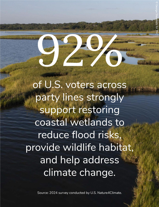
Blue carbon ecosystems, including seagrasses, salt marshes, tidal forests, and mangroves, are increasingly recognized as powerful nature-based solutions for mitigating climate change, also known as Natural Climate Solutions. These ecosystems can play a crucial role in sequestering carbon dioxide from the atmosphere. One study estimated that each acre of coastal wetland can sequester ten times more carbon than tropical forests. In addition, blue carbon strategies offer numerous co-benefits, such as enhanced resilience to storms and flooding, improved water quality, protection of wildlife—including commercially and recreationally valuable fish populations—economic advantages for coastal communities, and the preservation of areas important for cultural and spiritual practices. A recent survey conducted by U.S. Nature4Climate found that 92% of voters across party lines strongly support restoring coastal wetlands to reduce flood risks, provide wildlife habitat, and help address climate change. This widespread public backing highlights the growing recognition of these strategies as essential components in the fight against climate change. The combined climate mitigation potential and significant co-benefits provided by coastal blue carbon habitats are key reasons why states like Oregon, Louisiana, Maine,California, New Jersey, and North Carolina are harnessing blue carbon solutions into their climate change mitigation plans.
At the forefront of this crucial work is the Smithsonian Environmental Research Center (SERC), where dedicated scientists are uncovering the mysteries of blue carbon and its significance in addressing climate change. The U.S. Nature4Climate team spoke with scientist Jaxine Wolfe from SERC to learn more about their efforts to advance blue carbon and help states utilize it to meet their greenhouse gas reduction goals while delivering multiple benefits to communities.
The Importance of Blue Carbon as a Natural Climate Solution
“Wetlands are really excellent at a lot of things. They’re culturally significant, nursery habitat for commercial species of fish and crab, a place for refuge, nesting for waterfowl, and they provide storm surge protection and help absorb runoff,” Wolfe explained, highlighting the multifaceted value of these ecosystems beyond carbon storage. It’s essential to support the communities who rely on and benefit from these ecosystems. Thousands of people live in coastal areas, making it crucial to involve them in efforts to enhance their resilience against increasingly frequent and intense storms. “The educational aspect cannot be overstated because these are people’s backyards, and these communities will be the ones most vulnerable and impacted,” Wolfe stated. Additionally, empowering these communities to take action is vital. “Once people are aware, the next question often is, ‘What can I do? I want to help but feel powerless.’ It’s essential to create more opportunities to lower the barriers to community action towards protecting and restoring wetlands,” she emphasized. “This makes the whole effort stronger because people can directly connect to it and say, ‘I did that’ or ‘I advocated for that. Now we have living shorelines in our neighborhood instead of just gray infrastructure.'”
“Leveraging these ecosystems and how we find solutions using natural ecosystems to mitigate climate change impacts is really important. While they may not be the silver bullet, they’re a very important piece of the puzzle, and I think that they can do a lot for us. There are a lot of great infrastructure solutions coming online for climate mitigation, but we have natural ecosystems right here that can help us. There may be an initial investment to restore a degraded wetland, but that investment pays for itself over time. We need to have that long view.”
Jaxine Wolfe
“If we conserve, restore, or create these ecosystems and continue to treat them well, they’ll take care of themselves, and we don’t need to plug them in or charge them or mine resources to fuel them, for them to provide the ecosystem services that they do. Carbon capture is only one of these benefits, but I think maintaining that total ecosystem perspective is really, really important,” Wolfe added.
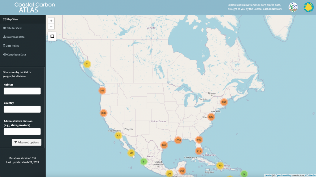
The Coastal Carbon Network: Bridging Science and Policy
“The Coastal Carbon Network is a consortium of coastal wetland scientists and practitioners in coastal land management,” explained Jaxine Wolfe. The network aims to accelerate discoveries in coastal wetland carbon science and improve ecosystem management. Wolfe emphasized the importance of a robust data foundation to inform policy and predict how these ecosystems will respond to future climate scenarios. “We build that foundation by facilitating the sharing of open data and analysis products,” she said, highlighting the network’s commitment to community feedback and stakeholder involvement. To accomplish this, the Coastal Carbon Network developed the Coastal Carbon Atlas, an interactive web application that “democratizes access to carbon stock and sequestration data for tidal wetlands worldwide, including marshes, mangroves, and seagrass beds”. Researchers and curious minds can explore, query, and download data from these critical ecosystems.
Another key initiative of the Coastal Carbon Network is the Blue Carbon Inventory Report Card. The report card assesses the quantity, quality, and coverage of data available in different states, providing a baseline for blue carbon assessments. “We provide recommendations for individual states on where data coverage is lacking,” Wolfe noted. This tool helps states understand their data needs and improve their data collection efforts to support blue carbon initiatives. Wolfe concluded, “The report card shows a state’s baseline and where improvements can be made in data coverage,” highlighting the network’s role in enhancing blue carbon data and supporting informed decision-making for coastal ecosystem management.
Strategies for States to Enhance Blue Carbon Assessments
Wolfe emphasized the critical need for investing in data stewardship to improve state blue carbon rankings and enhance greenhouse gas inventories. She advises states to allocate specific resources or funding for these efforts, making it a dedicated line item in their budgets. “Investing in data stewardship is crucial for building capacity to integrate coastal wetlands into greenhouse gas inventories,” she stated. Wolfe explained that data limitations often hinder progress and stressed the importance of political discussions to facilitate this investment, noting that providing context and understanding can garner necessary support.
Additionally, Wolfe highlighted the importance of preserving existing data and targeting new data collection to improve coverage. “We need to establish baselines for restoration and understand how ecosystems are changing,” Wolfe explained. Engaging stakeholders and finding common ground is also crucial for success. “Finding common ground and recognizing that data will guide us is essential,” she said. Targeted data collection should address gaps and enhance the comprehensiveness of blue carbon assessments, leading to better-informed decision-making and policy development.
Wolfe shared examples of successful utilization of Coastal Carbon Network resources by other states. “Pew, Silvestrum Climate Associates, and other Pacific Northwest researchers have used the database to develop white papers and influence policy,” Wolfe mentioned. For instance, the California Air Resources Board, working with the state’s Natural Resources Agency, leveraged findings from SERC’s data inventory efforts to encourage inclusion of coastal wetland habitats into their proposed climate change scoping plan. North Carolina’s Coastal Habitats Greenhouse Gas working group also cited the network’s work in their interim report in 2022 for the state’s first coastal habitat greenhouse gas inventory.
Wolfe highlighted the network’s collaboration with Silvestrum Climate Associates to update the National Greenhouse Gas Inventory, integrating new studies and estimates of carbon accumulation rates for vegetated coastal ecosystems. This update resulted in a significant increase in soil accumulation rates. “Between 1990 and 2022, the annual average increase in removals was 2.3 million metric tons of CO₂ equivalent,” Wolfe proudly shared, equating this to the mass of 15,000 blue whales over the entire time series. She emphasized the ongoing development of new tools, such as an inventory calculator, to provide more accessible and summarized data for stakeholders.
Overcoming Data Challenges in Coastal Carbon Science
Wolfe and the team at SERC face significant challenges in creating resources for the Coastal Carbon Atlas due to data inaccessibility and varying data-sharing cultures. “Often, the data exists but is not accessible,” Wolfe explained, noting that valuable information is frequently locked away in publications or on individual hard drives. This issue is compounded by researchers’ limited bandwidth or reluctance to share data due to personal investment. Wolfe stressed that “data sharing is built on trust,” and overcoming these challenges involves building strong relationships and ensuring researchers receive proper credit.
“The Smithsonian is known for its curation of an archive of historical artifacts and connecting this history to present day and making these resources accessible in a way that promotes learning and action. To me, data is also a historical artifact. It’s our record of these ecosystems. We are the conveners of that. We’re the librarians, in a sense. Each data set is like a book or a record, a snapshot, a moment in time. Putting all this information together allows us to have a more enriched understanding of these ecosystems. That’s why our database is referred to as the data library.”
Jaxine Wolfe
To address these issues, Wolfe and her team actively reach out to researchers to help archive and publish their data. “We were able to drum up some small funds internally to work with individual researchers at various institutions that had a lot of data that was not publicly available,” she said. Collaborating with researchers and students, they have published around 19 different datasets covering aspects such as carbon stock and accumulation rates. This effort not only makes the data accessible but also fosters a community of practice around data stewardship, emphasizing the importance of proper data curation and documentation.
Despite their efforts, the team faces challenges due to a small core group and limited resources, making their work time-consuming. Wolfe noted, “We curate data on a study-by-study basis, which is very time-consuming.” However, their dedication has resulted in documenting nearly 15,000 soil cores over seven years. They continue to seek ways to streamline the process and engage more researchers, enhancing the comprehensiveness and usability of the Coastal Carbon Atlas. Wolfe underscored the importance of promoting an open data culture to ease the sharing and integration of valuable information, ultimately aiming to make data more accessible and useful for researchers, policymakers, and community stakeholders.
Inspiration and Innovation: The Global Change Research Wetland at the Smithsonian
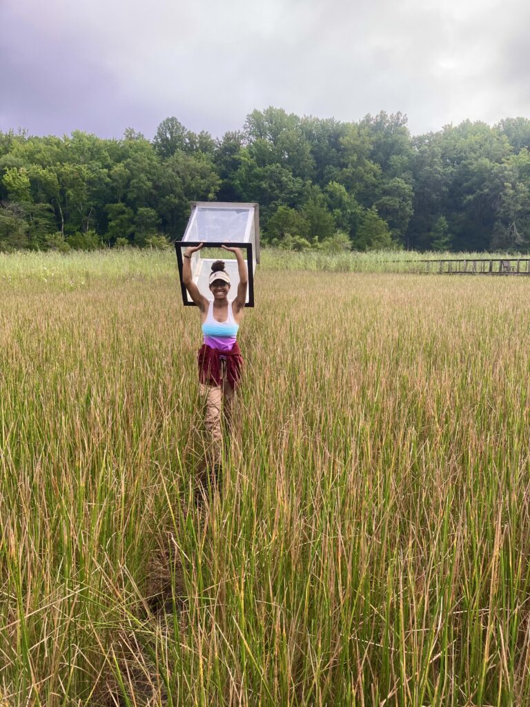
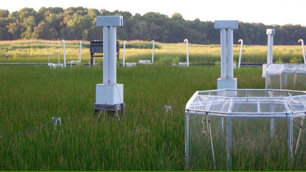
Left: Jaxine Wolfe carries a flux chamber out to the Hog Island field site at the Smithsonian Environmental Research Center which is used to measure the amount of greenhouse gases being released from the marsh. Photo by Sarah Parker. Right: Photo of the Global Change Research Wetland by the Smithsonian Environmental Research Center.
At the heart of the Smithsonian Environmental Research Center, the Global Change Research Wetland stands as a beacon of hope and inspiration for blue carbon science. “It’s one of my favorite blue carbon spots because of the important work being done there,” Wolfe stated. This marsh in the Chesapeake Bay region has been a living laboratory since the mid-’80s, exemplifying the power of long-term research and its profound impact on understanding our changing world. The pioneering CO₂ experiment—one of the longest-running of its kind—has not only revealed the effects of elevated atmospheric CO₂ but has also sparked innovative studies on sea level rise, nitrogen loading, warming effects, and invasive species.
Wolfe finds the ongoing research “inspiring and mind-blowing,” especially its exploration of “cross-terrestrial, aquatic interface interactions” and adaptation to phenomena like ghost forests emerging due to rising sea levels. Each visit to this vibrant ecosystem deepens her appreciation, as she reflects, “Every time I visit, it’s just so inspiring.” The interplay between field observations and experimental data at this wetland continuously enriches our models and validates predictive approaches, creating a dynamic cycle of discovery and action. For Wolfe, this wetland is not merely a research site but a powerful symbol of nature’s resilience and the relentless quest for knowledge, driving the pursuit of blue carbon science with every new question it inspires.
Harnessing Blue Carbon: A Pathway to Climate Resilience and Community Well-being
Blue carbon ecosystems play a vital role in sequestering carbon and offer a range of co-benefits to coastal communities. From storm surge protection to supporting fisheries and providing wildlife habitat, these ecosystems enhance the resilience of coastal regions. By engaging local communities, raising awareness about the value of blue carbon ecosystems, and involving stakeholders in restoration and conservation efforts, states can harness the full potential of these natural resources for climate change mitigation (Natural Climate Solutions) and community well-being. As we look towards the future, developing new tools and resources, such as an inventory calculator for coastal carbon, will further support state-level efforts to monitor and manage blue carbon ecosystems. By expanding our knowledge, engaging diverse stakeholders, and advocating for the protection and restoration of blue carbon habitats, we can make meaningful strides in addressing climate change and building a more sustainable future for future generations. The work of dedicated researchers like Jaxine Wolfe and organizations such as the Smithsonian Environmental Research Center is paving the way for a brighter, more resilient future driven by the incredible potential of blue carbon ecosystems.
Special thanks to the Pew Charitable Trusts for collaborating with U.S. Nature4Climate on this article.
Scientist Highlight: Jaxine Wolfe
Combining Passion and Skill: Jaxine Wolfe’s Work at the Smithsonian Environmental Research Center
“I’ve been at the Smithsonian Environmental Research Center for over four years now. I started in February of 2020, right before the pandemic,” said Jaxine Wolfe, a data scientist whose journey began with an undergraduate degree in biology from Northeastern University. “During this time, I took classes and pursued internship opportunities that were formative in crafting my foundational understanding of the ecosystems I work with now, and also in developing the data skills I use today.” Wolfe’s early experiences with coding in biostatistics and internships at institutions like Scripps Institution of Oceanography, Woods Hole Oceanographic Institution, and Stellwagen Bank National Marine Sanctuary shaped her expertise in data analysis, leading her to a role at SERC where she applies her skills in marine ecology and data science.
Wolfe emphasized the importance of understanding the context in which data is collected. “I believe in a well-rounded understanding… As someone working with this information downstream, it’s crucial. It gives you a better understanding of the field challenges and why data might raise questions,” Wolfe said. Wolfe’s work at SERC involves standardizing and analyzing data from various studies, ensuring they are comparable and reliable. Wolfe’s hands-on experience in the field, including international training programs and blue carbon projects, has deepened her appreciation for the data she works with, underscoring the value of fieldwork in informing data-driven research and policy.
Challenges in Land Management: Policymakers and land managers face the challenge of managing U.S. lands to support various needs like food and timber production, community resilience, biodiversity, and carbon sequestration, amidst unpredictable weather and growing global demands.
Role of U.S. Lands in Climate Change Mitigation: U.S. lands can both sequester and emit greenhouse gases. Increasing the land carbon sink while decreasing land-based emissions is essential to meeting climate goals.
Potential of U.S. Lands: Investments like the Inflation Reduction Act aim to enhance the resilience and health of U.S. lands. Analysis suggests that ambitious climate-smart forestry and agriculture initiatives could significantly increase the land carbon sink and reduce agricultural emissions.
Priorities for Land Managers and Policymakers: Strategies to protect and increase the land carbon sink include limiting land conversion, building ecosystem resilience, planning for economy-wide decarbonization, and promoting green infrastructure. Community involvement, equitable distribution of benefits, and innovative financing mechanisms are crucial for successful land management projects.
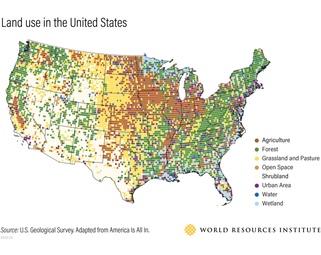
Policymakers and land managers face difficult decisions in an increasingly uncertain climate future. Lands must support food and timber production, help buffer communities from extreme weather, provide space for people to live and recreate, support biodiversity and sequester carbon. Managing land to meet all these needs while confronting unpredictable weather and a growing global demand for food and wood requires thoughtful and proactive action.
The U.S. lands sector, which includes forests, grasslands, wetlands, agricultural lands and agricultural operations, can remove carbon emissions to help curb the impacts of climate change, but it can also be a source of planet-warming greenhouse gas emissions. Activities like planting trees or conserving natural ecosystems increase what’s known as the land carbon sink, or the ability of land to sequester carbon. On the other hand, running farm equipment, fertilizing soil and plowing under native grasslands, releases greenhouse gases.
To reduce the most harmful impacts from climate change and support the U.S. target of reducing economy-wide net greenhouse gas emissions by 50% to 52% below 2005 levels by 2030, the land carbon sink needs to be increased and protected from future degradation, while lands-based emissions need to be decreased.
The Potential of US Lands
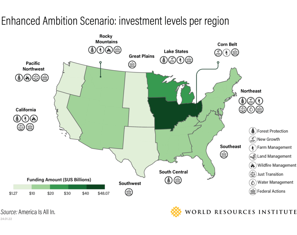
The Inflation Reduction Act of 2022, together with existing state forest and agricultural policies, are making critical investments in the resilience and health of the U.S. land base. But new analysis from America Is All In — a coalition of U.S. state and local leaders and organizations, including WRI — finds that the benefits from this investment are not yet secured. Effective implementation of climate-smart federal programs combined with increased state ambition and investment is required to protect and increase the land carbon sink.
In 2021, U.S. lands sequestered approximately 750 million metric tons of carbon dioxide equivalent (MtCO2e) per year, and agriculture emitted approximately 600 MtCO2e per year. Based on one set of models of the U.S. land sector, America Is All In finds that full implementation of the Inflation Reduction Act and other current federal and state policies, amounting to $42 billion of planned investment, would reduce agricultural emissions by about 8% or 48 MtCO2e per year over 2021 levels in 2035 and would increase the land carbon sink by about 1.5% or approximately 10 MtCO2e per year over 2021 levels in 2035. While a 1.5% increase is modest, implementation of current policies could help to reverse a projected decline in the land carbon sink.
With increased policy ambition and investment of approximately $160 billion in climate-smart forestry and agriculture the models find that the land carbon sink would increase by approximately 3%, or 24 MtCO2e per year in 2035. This high-climate ambition scenario would see a 13% reduction in agricultural emissions, or approximately 75 MtCO2e per year by 2035.
While America Is All In finds that these levels of land sector mitigation are enough to help the U.S. realize its climate goals alongside emissions reductions in other sectors, they do not realize the full potential of the land carbon sink. Otherstudies find much higher potential for reforestation, agricultural emissions reductions and other nature-based climate solutions, but maximizing the land carbon sink involves land use trade-offs. For example, planting trees can effectively sequester carbon, but planting new forests on large expanses of agricultural land could displace critical food production. Careful policymaking at the federal, state and local levels is needed to balance land use for food, fiber, biodiversity, climate mitigation and more.
What Should Land Managers and Policymakers Prioritize?
Protecting and increasing the land carbon sink will require an all-society effort. Federal funding like the Inflation Reduction Act can provide the foundation for action, but effective implementation takes place at the state and local level where the needs of ecosystems and communities are considered, while tradeoffs are weighed.
Despite historic levels of land sector funding in the Inflation Reduction Act, funding for many key projects is still limited and state and local leaders and their private sector and NGO partners need to prioritize actions that mitigate greenhouse gasses and increase resilience.
Here are four ways that policymakers, local leaders and land managers can prioritize strategies that will protect the land carbon sink and balance the many requirements for land use in the face of climate change.
1) Limit Conversion by Identifying Regional and Local Drivers of Land Use Change
While it is important to increase the land carbon sink, it is equally important to protect the carbon already stored in soils and vegetation. U.S. forests alone already contain about 60 gigatons of carbon, and they sequester an additional 700 MtCO2e each year. However, if forest ecosystems are severely damaged by logging or a natural disturbance, carbon stored in trees and soils is released to the atmosphere, and the ability of that forest to sequester carbon into the future may be diminished. This is also true of grassland and agricultural soils: Once carbon is lost, it takes intensive restoration and management to restore the carbon sink to pre-disturbance levels. This dynamic can be thought of as the “carbon cost” of clearing land for agriculture or development and not taking action to restore carbon stocks.
The factors that drive land use change vary regionally across the U.S. In areas where agriculture is a dominant industry, such as the Midwest, cropland expansion can drive the conversion of natural forest and grassland. Policies like the Renewable Fuel Standard that incentivize farmers to grow corn and soy for biofuels have contributed to the expansion of cropland into areas that are less productive and pose an outsized threat to habitat and biodiversity. Croplands have expanded by approximately 1 million acres per year between 2008 and 2016, leading to carbon emissions from the ecosystems that were converted.
The loss of cropland to commercial and residential development on some of the U.S.’s most productive soils is another driver of forest and grassland conversion. Urban expansion in many areas of the country displaces efficient agricultural production, requiring conversion to agriculture in other, less productive areas to compensate. The U.S. lost approximately 2,000 acres of prime farmland or ranchland every day between 2001 and 2016, and much of this land was converted to low-density urban development.
Forest loss due to land use change is an equally significant threat to natural carbon stores and ecosystem resilience. WRI’s Global Forest Watch finds that forest loss is most significant in the Northwest and Southeast regions of the U.S., and permanent deforestation is primarily driven by urbanization and commercial deforestation to accommodate demand for forest products. The U.S. lost 1.6 million hectares, or approximately 6,000 square miles of forest in 2022.
Policy approaches to curb land use change include:
Implementing urban zoning practices that create more dense and livable cities and protect prime farmland. For example, the state of New York has created a Farmland Protection Program that helps farmers maintain agricultural activity.
Making sure that biofuels and biomass policies include the true ‘carbon cost’ of biofuels to avoid incentivizing land use change and associated carbon emissions in the U.S. and abroad.
2) Build Resilience by Identifying Climate-related Factors that Threaten Local Ecosystems
Even though climate change affects all parts of the U.S., the key to managing ecosystems and lands for climate change is to identify the greatest health risks and then help them become resilient to change. Restoring an ecosystem often increases its carbon sink and resilient ecosystems and agricultural systems will reliably sequester carbon into the future.
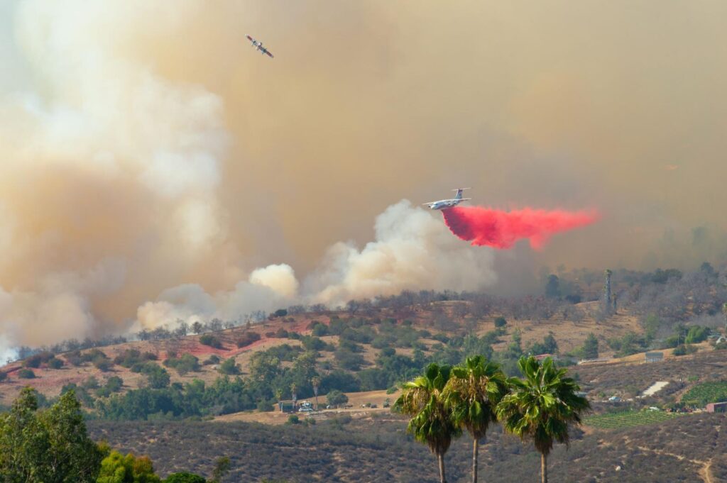
Forests in Western and Southwestern U.S. states face an increased risk of extreme wildfire due, in part, to climate change, which can damage forests and reduce carbon sequestration capacity in the future. While wildfire mitigation treatments may decrease forest carbon stocks in the short- to medium-term, these treatments can safeguard forests in the long-term. Forests in the Rocky Mountain region are predicted to be a net source of carbon dioxide through 2070 without significant policy intervention, which underscores the urgent need to manage forests for wildfire resilience. Across the U.S., forests also face destruction by pests and pathogens, exacerbated by climate change, which one report has estimated will cost the U.S. 50 MtCO2e every year.
A plane drops a fire retardant to battle flames in Southern California. U.S. Wildfires like those in California threaten ecosystems and impact their ability to sequester carbon. Photo by Randy Miramontez/Shutterstock.
In agricultural areas, climate-related extreme weather like drought, heat and flooding threatens crop production. Practices that build soil health like cover cropping or reduced tillage can increase crop resilience to flooding and drought. Agroforestry, or the practice of incorporating trees and shrubs into agricultural and ranching systems, can protect fields from erosion, improve water quality, provide wildlife habitat and sequester carbon. It is important that policymakers continue to support farmers in adopting these resilience practices as well as in reducing agricultural emissions by using targeted fertilizer application, improving livestock feed and reducing food loss and waste.
Carbon sinks in coastal areas are also under threat due to climate change. Sea level rise can flood wetlands and prevent them from providing water quality benefits and habitat for young fish. In many places, development in coastal areas prevents wetlands from migrating in response to sea level rise, so wetland ecosystems are permanently lost. Coastal development can also lead to draining or fragmenting wetlands which causes them to release carbon and methane.
Policy approaches to increase ecosystem resilience include:
Investing in risk mitigation treatments in areas with high risk of wildfires that improve forest health and resilience and reduce the risk of severe fire. For example, Colorado’s HB HB22-1011 created a grant program for local governments to undertake wildfire mitigation projects and education.
Providing forest owners in areas where diseases and pests threaten forest health with financial support to increase the health and carbon sequestration potential. For example, New York created a Forestry Cost Share Grant Program.
Establishing grant or cost-share programs to support farmers and ranchers in adopting resilience and emissions-reduction practices as the New Mexico Healthy Soils program has done.
In addition to sequestering carbon in soils and vegetation, lands will physically support economy-wide decarbonization. Building enough renewable power to meet U.S. climate goals will require 115,000 to 250,000 square miles of land to build wind and solar generation as well as new transmission lines to transport energy. But this doesn’t necessarily mean the land devoted to renewable energy can’t continue providing food and habitat.
Agrivoltaics, or the practice of using land for both solar generation and agriculture can provide shade for livestock and crops and provide farmers with an additional source of revenue. Livestock can also graze between wind turbines on rangelands in windy regions.
Local policymakers and land managers need to balance the protection of key wildlife habitat and farmland with the need for infrastructure build-out to reduce U.S. greenhouse gas emissions. Without immediate and ambitious action to reduce greenhouse gas emissions, climate change will continue to threaten the ability of lands to sequester carbon and provide services to communities.
Policy approaches to support responsible clean infrastructure buildout include:
Adopting zoning ordinances or other planning methods to facilitate renewable energy buildout that protects and enhances the most productive agricultural areas and protects key habitats. New Hampshire’s Model Solar Zoning Ordinance offers a framework for leaders to consider community goals and impacts of solar siting to support better decision-making.
Bringing together diverse interests to address barriers to large-scale solar projects and to balance the needs of nature, communities, and climate, as a group in California has done.
4) Increase Community Resilience by Identifying Opportunities for Green Infrastructure
As U.S. cities and towns experience increasing impacts from extreme weather, wildfire and sea level rise, the role of nature as a buffer has never been more important. Investing in nature as infrastructure to protect communities can mitigate the effects of extreme weather and provide water and air quality benefits. Many green infrastructure projects are also restoration and carbon sequestration projects. For example, restoring wetlands in and around cities can increase their ability to sequester carbon, filter water and protect coastal areas from erosion and storm surges.
Green infrastructure can save cities and utilities money by lowering water treatment costs and preventing weather-related damage, so innovative financing mechanisms are often available for these projects. WRI and Blue Forest’sForest Resilience Bond helps the U.S. Forest Service, local water utilities and other partners secure private finance for forest resilience projects that could save utilities millions of dollars in the long term.
While green infrastructure can provide important services to communities, these services are not equitably distributed. Urban trees and parks can cool city streets, sequester carbon and improve air quality, but many low-income neighborhoods have far fewer trees than wealthier neighborhoods. Improving tree equity in these neighborhoods is critical to creating livable cities for all residents and support local livelihoods.
Policy approaches to support green infrastructure include:
Adopting legislation that leverages private capital to fund restoration and environmental benefits like Maryland has done through its Conservation Finance Act.
Creating grant programs to support urban tree planting as Wisconsin has done through its Regular Urban Forestry Grants.
Accessing funds from the Infrastructure Investment and Jobs Act, which delivered $43.3 billion for state water quality projects, and is distributed through the State Clean Water Revolving Loan Funds. Some states, such as Ohio, have had success leveraging these funds for stream restoration projects that improve water quality.
A People-centered Approach to Land Management
Land management strategies that support local livelihoods and well-being while delivering climate benefits are more likely to have sustained success in the long term. However, securing positive local outcomes for a project can be challenging because opinions about land management can be deeply tied to cultural, spiritual and economic values. Project funders and policymakers may also have expectations about the outcomes of a project that do not align with local desires or expectations. Research suggests that the following strategies can create successful projects and policies:
Policy and project design should go beyond consulting local stakeholders — stakeholders should have continuous input starting from the initial stages of project development, as well as participate in project governance with clear dispute-resolution mechanisms in place. Initiatives should also involve all affected groups in designing and executing a project or policy, especially marginalized groups, to create durable and equitable outcomes.
Government agencies should create collaborative resource management approaches to managing state and federal protected lands. This allows tribes or local stakeholders to co-manage land with agencies.
Establishing Community Benefit Agreements can help guarantee local employment and other benefits to a community in exchange for their participation in a project.
Projects that remove carbon can be incorporated into climate resilience and adaptation planning to ensure that projects are beneficial to communities. Resilience, adaptation and climate mitigation projects should include funding for measuring and monitoring carbon and other benefits to make sure projects have impact over time.
This article was originally published by the World Resources Institute. Access the original article here.
Conservation, restoration, and improved stewardship of forests, wetlands, oceans, and farmlands around the world can provide up to a third of the emissions reductions we need to prevent the worst effects of climate change. These actions are frequently also some of the most cost-effective solutions available – and they’re ready for countries to implement today.
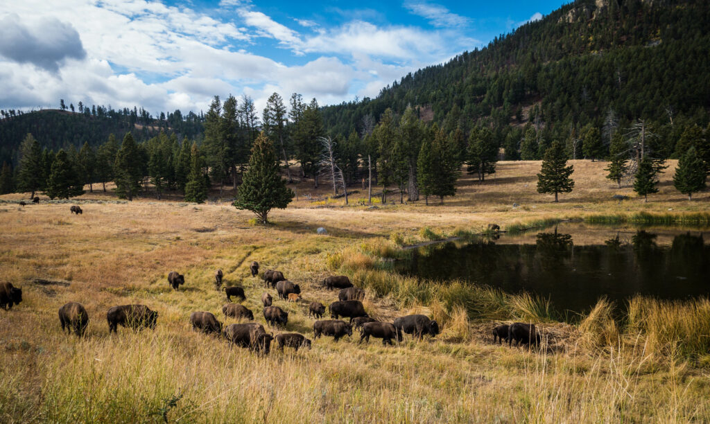
A herd of buffalo in Yellowstone National Park. Photo courtesy: CAJC/Flickr
Improving ecosystem management and restoring degraded habitats both hold huge promise to help us pull carbon dioxide from the atmosphere. Even if increasing carbon storage is the primary goal, making ecosystems healthier and more functional can also increase other essential ecosystem services. For example, improved forest management practices can reduce erosion and support water cycling processes, which can in turn reduce costs for communities who rely on forested watersheds for their drinking water.
Still, the expert body on climate change – the Intergovernmental Panel on Climate Change, or IPCC – identifies protecting and conserving existing ecosystems as one of the best options we have. In its latest reports, the world’s scientists concluded that only photovoltaic solar and wind energy have more potential for affordable climate mitigation than reducing ecosystem conversion. Many of the world’s ecosystems hold “irrecoverable carbon”, carbon they have captured and stored over decades or even centuries. If it is released because of human activity, these ecosystems could not re-capture that carbon in the next few decades, a critical period to reduce climate change.
Coral reefs, like this one at Palmyra Atoll National Wildlife Refuge, host a plethora of biodiversity and support thousands of species. Photo credit: Jim Maragos/U.S. Fish and Wildlife Service/Flickr
Biodiversity conservation is another huge benefit of avoiding the conversion of ecosystems to other land uses such as farming or urban development. Keeping ecosystem carbon in plants and soils also preserves valuable habitat for wildlife to forage and raise their young. For example, boreal forests and wetlands in North America, which hold enormous amounts of carbon in their soils, are home to mammals such as the woodland caribou and the snowshoe hare and offer essential breeding habitat to birds such as the whooping crane and the Cape May warbler.
World leaders and decision makers shouldn’t overlook our coasts at COP28, either. Actions to sequester and store “blue carbon” in oceans and coastal areas remain badly underfunded. Today, only 9% of all funding for nature-based solutions targets actions in marine areas. But conservation of carbon-rich coastal ecosystems would be a win for the climate and wildlife alike.
Take seagrass meadows: these lush underwater ecosystems pull carbon from the atmosphere at an astonishing rate and trap carbon-rich sediments among roots and stems. Although they only cover a fraction of a percentage of the ocean, researchers estimate that seagrass meadows are responsible for about 10% of carbon burial in the ocean. Yet seagrass meadows disappear at alarming rates. Key opportunities include addressing threats to seagrass meadows, such as nutrient pollution from rivers and disturbance of the seafloor related to fishing or mining, and restoring degraded meadows.
Our pathways for success are clear. What we need is to ensure sufficient funding is invested into natural climate solutions such as these for years to come. In part three of this series, we’ll explore how we can use natural climate solutions to adapt to the effects of climate change and increase community resilience.
IMPORTANCE OF ESTUARIES: Estuaries are crucial ecosystems, with over 40% of Americans living in estuary regions and almost 47% of the U.S. GDP coming from coastal areas. Additionally, nearly 70% of American seafood harvests rely on estuaries.
USFWS COASTAL PROGRAM: The U.S. Fish and Wildlife Service Coastal Program has partnered with various organizations for decades to protect and restore coasts, with a focus on estuary health and resilience, particularly in the face of climate change.
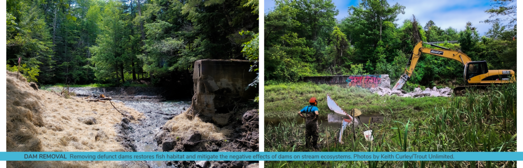
DAM REMOVAL PROJECT: A dam removal project in Frost Gully Brook near Freeport, Maine, supported by the USFWS Casco Bay Coastal Program, Trout Unlimited, and others, removed defunct dams to restore fish habitat and mitigate the negative effects of dams on stream ecosystems.
BENEFITS OF RESTORATION: Restoring native plants and riparian buffers along Frost Gully Brook provides shade, erosion control, and habitat for brook trout, while also sequestering carbon dioxide, thus contributing to climate change mitigation.
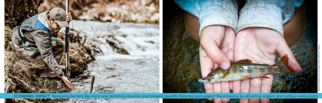
ECONOMIC IMPACT: Removing barriers like dams and restoring estuaries and streams not only benefit fisheries but also support the economy by attracting anglers and outdoor enthusiasts.
SUPPORT NEEDED: Partnerships between organizations, governments, and private entities are crucial for achieving conservation goals, and increased funding is needed to sustain these efforts and address climate and coastal resilience challenges.
One of the key programs in place to protect and restore estuaries is the U.S. Fish and Wildlife Service Coastal Program, a voluntary program that has built its legacy on supporting partnerships in coastal communities for the better part of four decades – working alongside private landowners, non-profits, and various government agencies to restore and protect coasts. Restore America’s Estuaries (RAE), a national alliance of coastal restoration organizations, has been a longstanding partner of the Program, working together with the Service and our various partners to support the mission of the Service and to improve the health and resilience of estuaries, particularly in a changing climate.
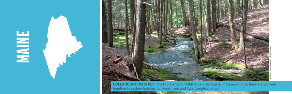
An important facet of a healthy estuary is connectivity between rivers and the sea. One such project opened miles of free-flowing river upstream from the Casco Bay estuary near Freeport, Maine.
With support from the USFWS Casco Bay Coastal Program, Trout Unlimited (TU), Freeport Conservation Trust, and other local groups completed a project which opened miles of habitat for migratory fish on Frost Gully Brook, a tributary of the Harraseeket River and Casco Bay. The groups removed three defunct dams in the Summer of 2023, and will now embark on a comprehensive stream restoration effort, including work to replant native trees and plants along the stream’s banks.
In addition to blocking fish passage, dams like those in Frost Gully Brook also raise temperatures in streams by pooling water, block the free flow of nutrient rich sediments to flood plains and downstream estuaries, and create increased flood risks to downstream communities.
The native plant and riparian buffer restoration on Frost Gully Brook will also provide shade to the stream during the summer months, protect from unnatural erosion of stream banks, and provide habitat for brook trout and other species. These trees and plants also help mitigate climate change by naturally removing and sequestering carbon from the atmosphere. Indeed, according to the Reforestation Hub, reforesting streamside buffers has the potential to sequester 10 million tons of carbon dioxide a year nationwide.
Restoring For the Future
The source and much of Frost Gully Brook is cold water spring influenced, which keeps water temperatures at safe levels for native brook trout; typically, less than 65 degrees Fahrenheit year-round. The newly accessible sections of river will allow these fish to migrate to traditional spawning areas as well as access cooler waters in the warm summer months. According to Keith Curley, Vice President of Eastern Conservation at Trout Unlimited, “the water temperatures on Frost Gully Brook in the hottest part of July were no higher than 66 degrees in the headwaters but warmed up to 74 degrees behind a dam downstream. Removing these dams will help to keep water temperatures within the tolerance range of brook trout.”
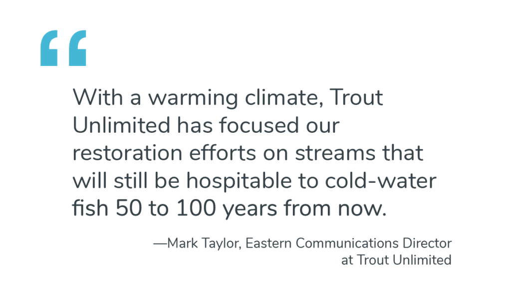
“Given the naturally low water temperatures, Frost Gully Brook is already resilient to warming air temperatures as climate change increasingly threatens our nation’s cold-water fisheries. This made it the perfect site for dam removal and restoration”, said Mark Taylor, Eastern Communications Director at TU.
The reconnected stream also presents anglers with new opportunities. Aside from the resident brook trout, Frost Gully Brook is also home to a subpopulation of salter brook trout. The Salters, although genetically identical to resident fish, travel freely between fresh and saltwater and tend to grow much larger than resident brookies. Sea-run brook trout are unique to New England and Canada where cold-water streams flow directly into the ocean rather than traversing through warmer coastal plains, such as those in the Mid-Atlantic and Southeast United States.
“Brook trout need clean, cold water to survive, so they can tell you a lot about the health of a watershed. If brook trout are doing well, then it’s a safe bet that other fish and wildlife are doing well too” said Mr. Curley, again. “This is especially important along the coast, where development can harm water quality and watershed health. If we can keep strong populations of brook trout in coastal streams, we will know we’re taking good care of our watersheds.”
Fishing and the Economy
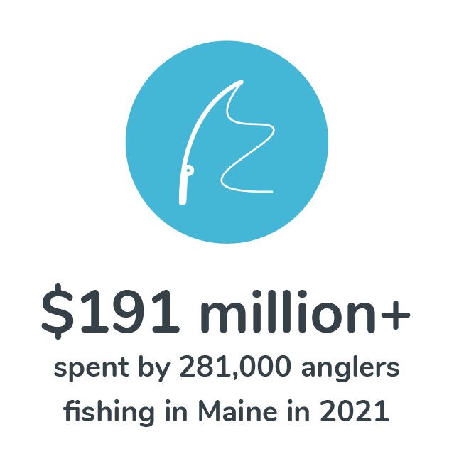
Maine is a well-known destination fishery with a long-standing tradition and allure that attracts anglers from all over the world. In addition to salter brook trout, the state is home to some of the last remaining populations of wild landlocked and anadromous Atlantic Salmon in the United States. According to the American Sportfishing Association, more than 281,000 anglers spent upwards of $191 million fishing in Maine in 2021.
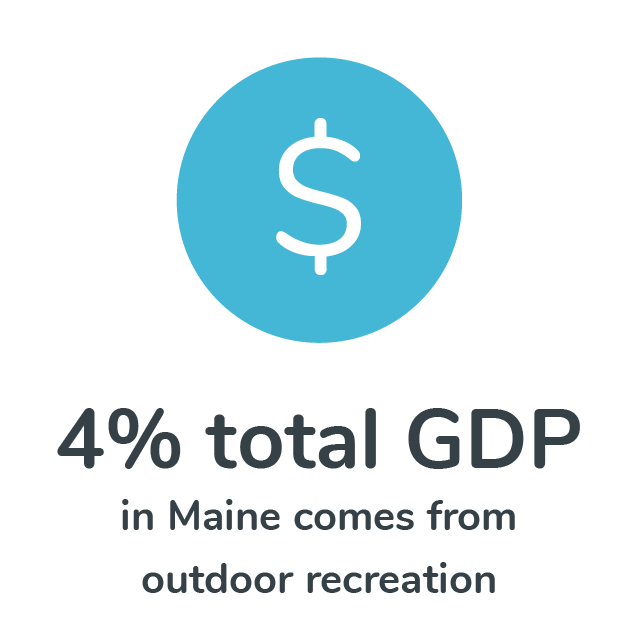
Outdoor recreation accounted for just under 4% of Maine’s total gross domestic product (GDP), putting it in the top five states in the U.S. in value of outdoor recreation added to state GDP, according to the Maine Office of Outdoor Recreation. The state is also home to one of the largest outdoor retailers in the world, L.L. Bean, whose Freeport headquarters sit just a few miles from the Frost Gully Brook dam removal sites.
Improvements such as dam removal and stream restoration help support this robust economic driver by offering more and more diverse opportunities for anglers, hikers, and other recreation enthusiasts to enjoy. When they come to town, fishermen and women pay for guides, equipment, lodging, food, and fuel, as well as secondary and tertiary tourism related businesses (think housecleaning, insurance, construction). In rural communities, fishing and other outdoor activities can often stand up the entire local economy. Protecting and restoring streams and estuaries, and the fish they support, has much larger ramifications for the broader region.
Building Conservation Partnerships
Partnerships like this between the Coastal Program, non-profits, state and municipal governments, and private partners are quintessential for achieving climate goals and protecting climate susceptible species, like brook trout.
Since its founding in 1985, the Program has engaged more than 8,200 conservation partners to complete roughly 5,000 conservation projects, improved 600,000+ acres, and protected another 2.3 million acres of priority habitat, while supporting the down-listing of at least 15 endangered and threatened species. In 2022 alone, the program leveraged its investment to secure an astounding 9:1 match from partner funding sources.
“Building partnerships also builds consistency which can translate to more funding, less disruption, and creates stronger long-term relationships” said Samaya Rubio, Community Engagement Associate with RAE. “The Coastal Program is more than just a funding source, they’re a convener, bringing together diverse partners to achieve common goals.”
Despite its long track record of success and increased demand, the Coastal Program has been consistently underfunded and understaffed since its inception. Annual appropriations for this critical program have hardly increased since at least 2014.
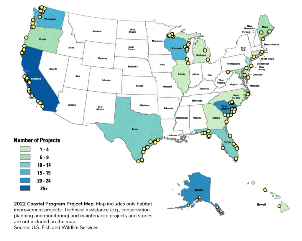
Beyond supporting fish passage improvements in Maine, the Coastal Program works diligently in 24 priority estuaries across the country to secure shorelines using nature-based processes, restore marsh and wetland habitats to sequester carbon and protect communities from storms and flooding, and engages private landowners, such as farmers and developers, in best practices to maintain healthy coastal ecosystems while also improving economic opportunities.
Program staff also provide expertise, resources, equipment, historical knowledge, and create an invaluable network of local restoration and conservation professionals. These partner building efforts also help reduce redundancy and streamline restoration.
Without adequate funding, though, the Program is unable to maintain these relationships and thus critical projects are left in limbo due to either lack of resources or expertise, and oftentimes both. Legislation is currently moving through both Chambers of Congress (H.R. 2950 and S.1381) that would strengthen the coastal program’s financial footing and, for the first time since its founding, provide Congressional authorization.
If passed, the strength and success of the Program can grow exponentially, providing another tool to reach our climate and coastal resilience goals, and providing countless recreational opportunities for anglers not just in Maine but throughout the United States.
Rob Shane is the Senior Manager of Communications for Restore America’s Estuaries (RAE) based in Washington, DC. He is an avid angler who can often be found searching for native brook trout in the Blue Ridge Mountains.
I remember the exact moment when I began my relationship with seagrass: rooted, flowering plants growing completely underwater in a shallow lagoon off the Florida Keys. It was my 21st birthday, and I was far from my Eastern Shore of Maryland home and college, immersed in a Tropical Marine Ecology “winter-mester.” My fins and dive gear were brand new, as was my scuba certification.
I forgot everything I had learned in my scuba training as I pulsed through the most beautiful, submerged ecosystem I had ever seen. It took my breath away—literally. My dive partner had to circle back to check on me. I tried to speak to her with bubbles and gestures: “Have you seen this grass? Have you seen the fish and other animals in this grass? The sandy bottom? Have you ever experienced anything like this?”
“I mean, sure, it is beautiful,” her eyes said to me through her mask. But come on, let’s swim to the coral reef!”
That experience changed the entire trajectory not only of my professional life, but also my entire life.
In Virginia, the water in our temperate eelgrass beds is not as clear as in that tropical system. But the seahorses, the fish, the blue crabs, the amazing way the grass holds sediment and captures wave energy—it all still takes my breath away. And the fragility of these meadows. Though able to alter the water clarity with roots and rhizomes holding the sediment in place, they can be harmed by runoff from the land that brings excess nutrients and sediments, blocking light essential for survival.
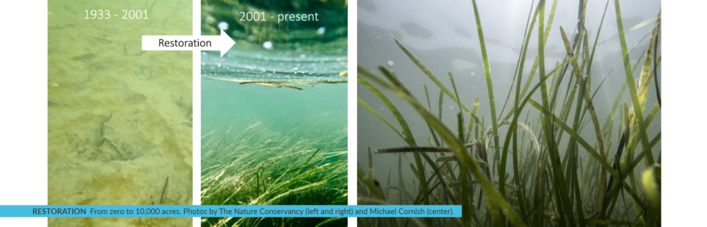
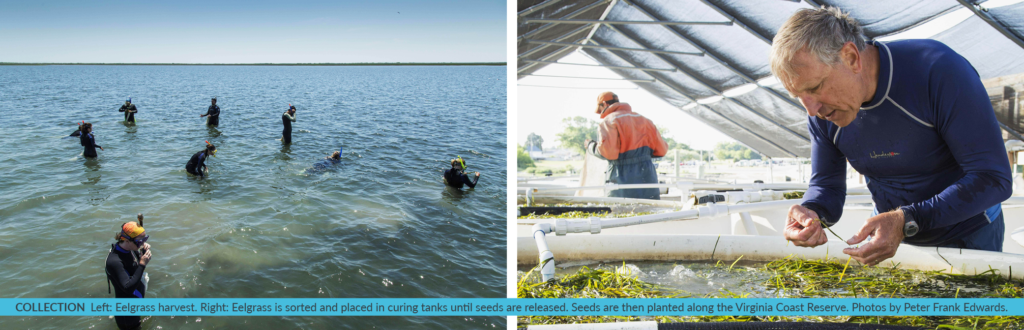
The story of eelgrass along the East Coast of the U.S.—human impacts, loss and disease taking hold to strangle out this vital underwater “forest”—is one that has been repeated across the globe. Here off Virginia’s Eastern Shore, eelgrass disappeared from our coastal lagoons in the 1930s. Zero. We were down to zero acres, and all the benefits of this grass—habitat, refuge, erosion control, atmospheric carbon capture—disappeared with it. Then, in the late 1990s, scientists found a small patch of eelgrass1. They had been my colleagues back during the first seagrass experiences, when I was a graduate student at the Virginia Institute of Marine Science (VIMS).
The Nature Conservancy and partners had invested in the conservation of this barrier island coastal system for decades, so maybe the protected water quality here in these shallow lagoons would support eelgrass once more?
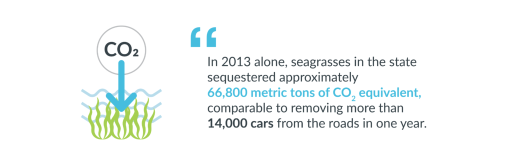
Using a simple seed-dispersal technique, scientists and volunteers from all over the world have contributed to what is now 10,000 acres of thriving eelgrass in the Virginia Coast Reserve (VCR). This local restoration is now informing global science and recovery as well as providing further improvements to local water quality, five times more fish abundance, higher blue crab densities, return of bay scallops and capture and storage of atmospheric carbon in the soil and plant material. In twenty years, these seagrass meadows have captured 5,000 tons of carbon— equivalent to the yearly carbon dioxide emissions of 3,500 cars!
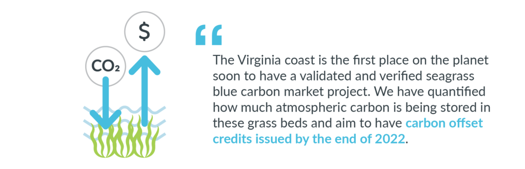
Our coastal systems are among the most studied in the world— and home to the University of Virginia’s Long Term Ecological Research program2. And here is where a methodology to quantify the amount of carbon that is being sequestered in seagrass beds was developed. Methodologies for carbon projects provide the procedures for quantifying greenhouse gases in habitats, like restored eelgrass beds. Standard-approved methodologies are used to generate carbon offsets, which can be sold on the voluntary market.
The restored eelgrass in Virginia’s coastal bays is one of the great large-scale success stories in marine restoration, and now it’s the first place on the planet soon to have a validated and verified seagrass blue carbon market project. We are now in the final stages of the approval process. We have quantified how much atmospheric carbon is being stored in these amazing grass beds and aim to have carbon offset credits issued by the end of 2022—establishing a model for similar seagrass restoration projects worldwide.
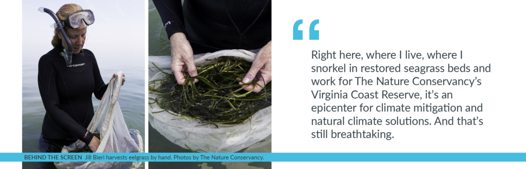
Since the Commonwealth of Virginia owns the sandy bottom on which this successful restoration has taken place, state legislation was proposed, supported, and passed in 2020 allowing carbon market participation by the Commonwealth. This legislation stipulates that revenue generated would be used for further monitoring and research in these eelgrass beds—a win-win for the state. This brings the project full-circle, as 20 years ago, initial funding for this endeavor was provided by Virginia’s Coastal Zone Management program. Right here, where I live, where I snorkel in restored seagrass beds and work for The Nature Conservancy’s Virginia Coast Reserve, it’s an epicenter for climate mitigation and natural climate solutions. And that’s still breathtaking.
Please visit the Virginia Coast Reserve website to learn more.
1 In the 1990s, scientists from the Virginia Institute of Marine Science (VIMS) found a small patch of eelgrass and figured out how to restore it in this system. They have spearheaded the restoration work ever since.
2 The University of Virginia’s Long Term Ecological Research program developed the methodology that is being used to quantify the amount of carbon that is being sequestered in seagrass beds.
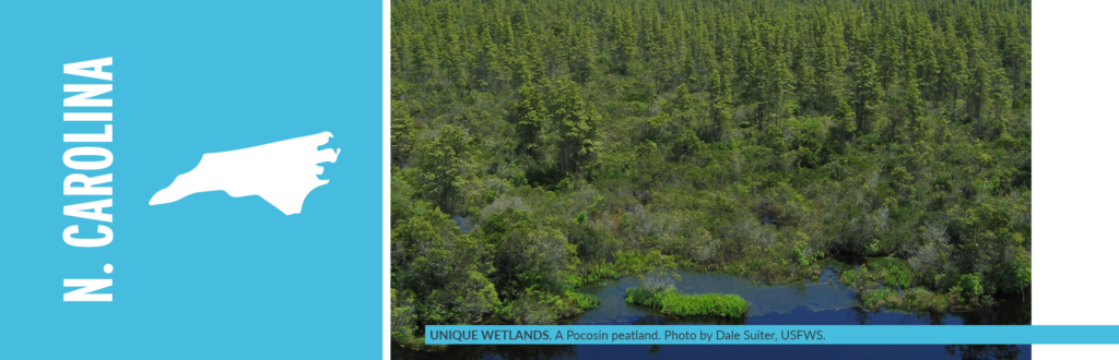
The Nature Conservancy is restoring the hydrology of peat soils in coastal North Carolina to combat climate change.
The Atlantic coastal plain along the Southeastern United States (SE US) holds powerful potential in its peatlands. These unique wetlands store carbon from waterlogged plant material dating as far back as 10,000 years. But they also capture carbon across their living landscape of forest and shrub communities.
Like many other peatlands across the world, large portions of the network of bogs and swamp forest that once stretched over millions of acres in the SE US have been ditched and drained. Restoring these drained peatlands is proving to be a critical natural climate solution.
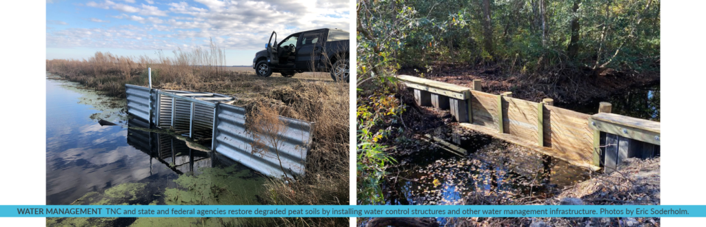
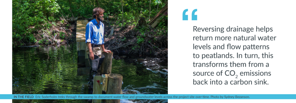
“This work is a giant plumbing job of sorts,” says Eric Soderholm, restoration specialist for The Nature Conservancy (TNC) in North Carolina. “Reversing drainage helps return more natural water levels and flow patterns to peatlands. In turn, this transforms them from a source of carbon dioxide emissions back into a carbon sink.”
Peatlands are a type of wetland whose soils contain a high amount of partially decayed organic matter that has accumulated very gradually over thousands of years. They retain an incredible amount of carbon in their ever-growing layer of peat soil. Peatlands cover just 3% of the earth’s surface but store more than twice the carbon as all the world’s forests combined. They span tropical rainforests, permafrost regions and coastal areas.
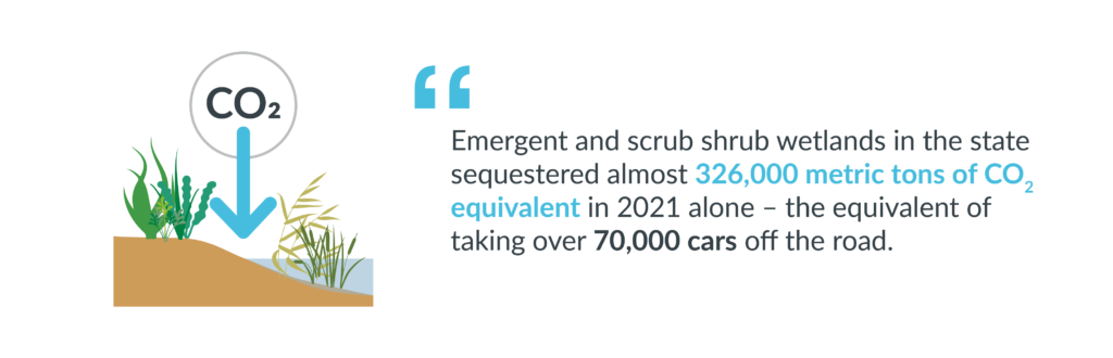
Approximately 1.2 million acres of peatlands in the Southeastern U.S., and 70% of those found in North Carolina, have been ditched and drained. Drained peatlands emit carbon dioxide. Restored peatlands retain carbon. Think of it this way: 10 acres of natural, undrained peatlands in the Southeast can remove 5.3 passenger vehicles’ emissions in a year. In contrast, 10 acres of drained peatland can add 21.5 passenger vehicles’ emissions. Yet, this comparison does not even consider emissions from peatland wildfires. Due to its rich carbon content, unnaturally dry peatland soils are highly flammable. This makes them vulnerable to more frequent and intense catastrophic wildfires that can burn several feet deep into a peatlands soil and belch huge quantities of carbon dioxide in a single event.
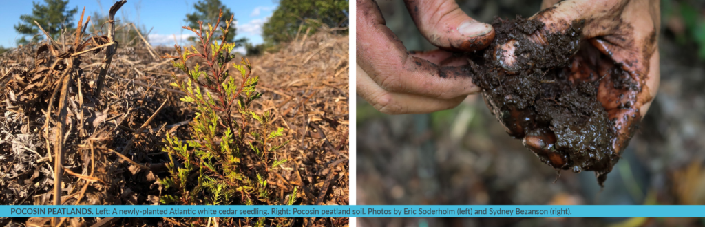
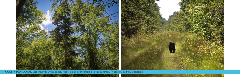
The Nature Conservancy in North Carolina and its partners have been steadily restoring peatlands including portions of the U.S. Fish and Wildlife Service’s Great Dismal Swamp, Pocosin Lakes and Alligator River National Wildlife Refuges. The distinctive peatlands found on the coastal plain from Virginia to Georgia represent many wetland communities that are broadly called “pocosin”, an Algonquin word. Plants here are diverse, yet all share an affinity for soggy soil conditions: pond pine, Atlantic white cedar, swamp tupelo, cypress, loblolly bay, inkberry, fetterbush, canebrake, pitcher plants, cranberry, sphagnum moss. If you grab a handful of pocosin peatland soil, half of what you are holding is carbon.
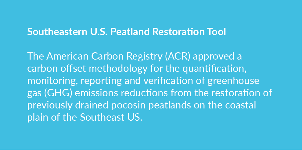
TNC developed this one-of-a-kind carbon methodology with TerraCarbon, a carbon offset project and natural climate solutions advisory firm. The methodology has been put into practice at a 1,241-acre proof-of-concept restoration site within Pocosin Lake National Wildlife Refuge, in partnership with the US Fish and Wildlife Service. Much of the peatland that remains drained in the SE US is privately owned. This tool allows landowners to register new projects with the American Carbon Registry to generate and sell verified carbon credits on the voluntary carbon market based on the emission reductions achieved by a peatland rewetting project. Income from the sale of verified carbon credits can help cover upfront restoration costs required to successfully rewet and monitor drained peatlands.
Eric Soderholm leads TNC’s work to restore peatlands in North Carolina, partnering with state and federal agencies to restore degraded peat soils by installing water control structures and other water management infrastructure throughout each project site.
On his days monitoring TNCs most recent restoration project within Great Dismal, Soderholm treks through the swamp to document water flow and groundwater levels across the project site over time. “It is fascinating to watch water return to the peatland,” says Eric Soderholm. “Once we know how water moves and fluctuates, Refuge staff can use this information to adjust that water flow to maximize both the habitat and flood resilience enhancements restoration provides.”
When peat soils are rewetted, they are much less flammable and create conditions for more diverse and resilient wetland forest communities to thrive. Since peat soils also have the great potential to sequester carbon when saturated with groundwater, restoring more natural water patterns in peatland is a natural climate solution. Most recent conservative estimates from the Duke University Wetlands Center suggest that if the remaining drained peatlands in the SE US were restored, emission reductions of at least 2.66 million metric tons of carbon dioxide could be achieved every year.
Once the “plumbing” is right at a peatland restoration site, rewetted conditions allow the re-establishment of peatland specialist native plants such as Atlantic white cedar. Cedar-dominated forests, which are now a globally threatened community, thrive in peaty, moist soil of swamps and bogs. Peatlands also support a variety of wildlife. Many songbirds, such as the prothonotary warbler, seek refuge there in spring. In the summer, black bear forage and enjoy the extra sun.
People also benefit. Improvements on Refuge lands help slow down and absorb storm water before it reaches a farming community just downslope from restoration sites, potentially reducing damage to crops and property.
Likewise, restoring peatlands vastly reduces the risks to human health and community safety associated with the numerous catastrophic peat wildfires this region has recently endured. A study following North Carolina’s 41,000-acre Evans Road peatland fire in 2008 determined that emergency room visits for cardiopulmonary complications increased significantly in the counties exposed to its toxic peat smoke.
Pocosin peatlands naturally sequester nitrogen and mercury which leach from drained sites at much higher rates. Restored sites with water control infrastructure help to reduce the quantity of these contaminants entering our rivers and sounds, both of which can impact aquatic communities and commercial fisheries.
TNC initially focused its partnership efforts to restore peatlands at sites on federal lands across the coastal plain. The organization is now moving south to state lands managed by the North Carolina Wildlife Resource Commission at Angola Bay Game Land. There are still large swathes of peat to be restored from Virginia to Georgia. TNC’s implementation work and partnership with researchers has helped lay the groundwork for that restoration. One of the next most critical steps is to expand restoration progress to the significant acreage of privately-owned drained SE US peatlands.
Interest from carbon project developers to work with private peatland landowners has continued to grow since the release of the ACR carbon offset methodology. Layering carbon finance with both existing and emerging state, federal and other funding sources is beginning to create the incentive needed for landowners to pursue the many benefits peatland restoration projects can yield.
“We’ve worked diligently with our partners to get the plumbing right at many sites in Northeastern North Carolina,” says Eric Soderholm. “This work has helped to demonstrate what can be accomplished elsewhere.”
Why are peatlands being degraded or destroyed?
European settlers gradually drained peatlands along the coastal plain at first to reach high value timber for human settlement and export and for agricultural conversion. Technological advances in modern excavation equipment fueled a boom in the 20th century to convert peatlands to agriculture, pine plantation and experiment with mining peat as a fuel source. However, significant acreage that was previously drained and logged are no longer in any active productive use yet continue to experience the negative impacts from historic ditch networks. Developmental pressures continues to loom for some of these special natural areas.
Why does peat burn?
Peat is highly flammable when dried. When wildfires occur in degraded, dry areas, they have devastating impacts on the land, as they can continue to smolder for long periods of time. Their emissions can also affect human health.
How can landowners get involved?
Landowners can access the peatland restoration methodology through the American Carbon Registry.
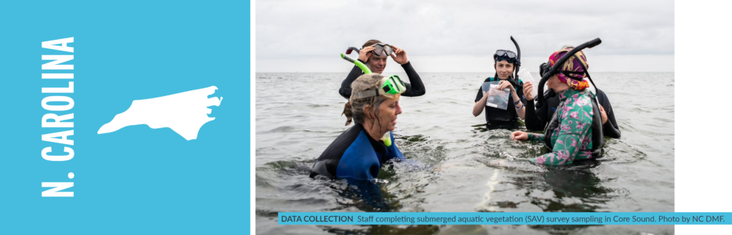
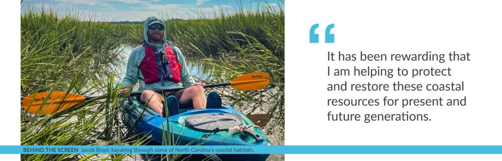
For most of my life, I have lived along the North Carolina coast enjoying my time spent in its coastal habitats and admiring its natural beauty. These experiences are an integral part of who I am. After I completed my undergraduate degree, my time spent appreciating the coast motivated me to begin a job as a Fisheries Technician for the North Carolina Division of Marine Fisheries. As my career has progressed with the division, it has been rewarding that I am helping to protect and restore these coastal resources for present and future generations.
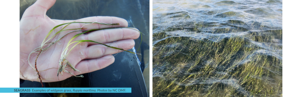
As the Habitat Enhancement Section Chief for the North Carolina Division of Marine Fisheries, it’s my job to lead my team of highly skilled individuals to manage and coordinate large-scale restoration, management and enhancement programs – such as the North Carolina Coastal Habitat Protection Plan (CHPP) – for the diverse and critical habitats in our nearshore, coastal and estuarine areas that support the state’s commercial and recreational fisheries. The overarching goal of the CHPP is for long-term enhancement of coastal fisheries through habitat protection and enhancement efforts including conserving coastal ecosystems like salt marsh and seagrasses which provides many benefits to the state.
North Carolina has over 220,000 acres of salt marsh and the largest extent of seagrass coverage along the Atlantic coast, measuring approximately 105,000 acres in 2013. Seagrass is a common term used to define high salinity submerged aquatic vegetation (SAV), which is habitat characterized by the presence of plants that are rooted into the ground and remain under the surface of the water during all tidal stages. The foundation of North Carolina’s coastal economy is based on the abundance of healthy habitats in its 2.9 million acres of coastal waters. Fishing, outdoor recreation, and tourism all depend on a healthy ecosystem. In addition to providing a critical home for fish, coastal habitats help reduce the impacts of severe storms, improve water quality, support birds and other wildlife, and sustain culture and a North Carolina way of life. Unfortunately, increasing stressors from a variety of land use activities, coupled with climate change, threaten the health and sustainability of the state’s coastal ecosystems. Protecting and restoring these areas so that they can continue to deliver important benefits to people and nature is key. Over the last two years, researchers and managers have been assessing another benefit provided by these coastal habitats – slowing climate change.
Coastal wetlands, including salt marsh, seagrass, and mangroves, are incredibly efficient at capturing and storing carbon in their leaves, stems, roots, and soils. Blue carbon is a common term used to define carbon captured by the world’s ocean and coastal ecosystems. Coastal wetlands can keep this blue carbon locked away for thousands of years if left undisturbed. However, when these ecosystems are degraded, stores of carbon and other greenhouse gases (GHGs) are released back into the atmosphere, which can accelerate climate change. Given their carbon storage benefits, many U.S. coastal states, including North Carolina, and countries around the world, are interested in protecting and restoring blue carbon habitats as part of their climate response strategies.
A key first step to account for the carbon captured and stored in these habitats is through the development of a GHG inventory. Accounting for coastal habitats in GHG inventories is relatively new – the U.S. EPA began incorporating coastal wetlands into the national GHG Inventory in 2017, and in 2022 started making these data available to states. But – until now – national and state inventories have lacked a key habitat – seagrass beds. North Carolina is poised to address this omission.
In 2018, Governor Cooper of North Carolina signed Executive Order 80 – North Carolina’s Commitment to Address Climate Change and Transition to a Clean Energy Economy – which includes a statewide goal to reduce the state’s GHGs to 40% below 2005 levels by 2025. The Natural and Working Lands Action Plan, published in 2020, outlines specific projects in the Natural and Working Lands (NWL) sector – including coastal habitat protection and restoration – that advance North Carolina’s climate goals by enhancing carbon sequestration, building community and ecosystem resilience, and supporting local economies.
Several subcommittees, including the Coastal Habitats Subcommittee that I chair, contributed to the recommendations of the Natural and Working Lands Action Plan and continue to support its implementation. One of the next steps spawned by the plan is the development of a GHG inventory for the state’s coastal wetlands, including emergent, scrub shrub and seagrass habitats, to help us better understand how much blue carbon is captured and stored in these areas, and what management steps we can take to enhance our blue carbon resources. As the chair of the Coastal Habitats group, I am technically in charge of the inventory development process, but I have two great champions in Paul Cough and Chris Baillie, who are leading this effort with a stellar working group comprised of federal and state agency staff, NGOs, academics, and GHG inventory experts. Once finished, North Carolina will have one of the world’s first blue carbon inventories that includes seagrasses.
A robust blue carbon inventory relies on mapping and activity data to estimate the extent of coastal wetlands and how these habitats are changing over time. These data are then applied to corresponding “emission factors” to estimate GHG emissions and removals (i.e., sequestration) occurring in coastal areas. Although North Carolina has extensive seagrass mapping, data gaps still exist. To deal with this uncertainty, the working group utilized the expert opinion of world-renowned researchers and practitioners from along the Atlantic coast during two workshops this past spring. We also benefitted greatly from ongoing blue carbon research in our neighboring state of Virginia, whose seagrass ecosystems are very similar in species and distribution as those we have in North Carolina. Other states looking to develop blue carbon inventories can rely on expert opinion when filling in data gaps as well.
Though our work to develop the first blue carbon inventory for the period 1990-2021 will continue through early 2023, we have an initial set of findings for seagrasses that demonstrate their importance as a blue carbon habitat: in 2013 alone, seagrasses in the state sequestered approximately 66,800 metric tons of carbon dioxide equivalent, comparable to removing more than 14,000 cars from the roads in one year. Unfortunately, the inventory also shows that seagrass habitats are on the decline, with slight decreases in GHG removals taking place over the years. In addition, emergent and scrub shrub wetlands in the state sequestered almost 326,000 metric tons of carbon dioxide equivalent in 2021 alone – the equivalent of taking over 70,000 cars off the road. Collectively, these coastal wetlands store 48.8 million metric tons of carbon, showing how important it is to maintain the health of these habitats to keep blue carbon locked in the ground and out of the atmosphere.
The blue carbon GHG inventory will help bolster North Carolina’s efforts to protect and restore coastal habitats, including specific actions called for in the CHPP to improve the health of seagrass. When finished, the inventory will provide a tool for managers to account for the blue carbon benefits of new CHPP measures to conserve and restore seagrass habitats, such as reducing threats related to poor water quality through improved land management upstream.
We plan to release an interim update of initial findings, methodologies, and next steps for North Carolina’s Coastal Wetlands GHG Inventory by the end of 2022. In 2023, we will incorporate new seagrass mapping data, which will improve understanding of coastal wetland extent and how these habitats have changed over the inventory period (1990-2021). The North Carolina Department of Environmental Quality plans to integrate the blue carbon inventory into the state’s next sector-wide GHG inventory update in January 2024. Once this happens, North Carolina will be the first state in the nation to account for seagrass in its GHG inventory, setting an example for other states to inventory their own seagrass ecosystems.
The process by which the workgroup developed the first GHG inventory for seagrass in the US can provide a model for other states to estimate the carbon value of their seagrass habitats. Throughout development of the inventory, the workgroup operated by the motto “don’t let perfect become the enemy of good.” This means that entry points exist for states to begin developing GHG inventories, even in the absence of perfect data, by incorporating expert input and learning by doing.
I have been inspired by the time and dedication of all the people involved in this effort to help North Carolina develop its first blue carbon inventory. We have had researchers up and down the coast, from Maine to Florida, share their knowledge and provide advice. We still have a lot of work to do, but I know we’ll continue to make progress to better understand and leverage the blue carbon benefits of our coastal habitats.